1950s Maps of Lawrenceburg, Kentucky
Explore 4 historic maps of Lawrenceburg from the 1950s. These maps offer a rare glimpse into what life looked like during the 1950s — showing old roads, neighborhoods, homes, and landmarks that have changed or disappeared over time.
Whether you're researching your family's past, planning a metal detecting trip, or studying how Lawrenceburg's landscape evolved across the 1950s, these high-resolution maps are a powerful tool for exploring the history of this region.
- Focus on a specific era: All maps on this page are from the 1950s, giving you a focused view of this time period.
- See what’s changed: Compare century-old streets, trails, and buildings to today's modern landscape using overlays and satellite layers.
- Research with precision: Use these maps for genealogy, historical research, land use analysis, or educational projects.
- View, download, or print: Maps are fully viewable online in high resolution, and can be downloaded or printed for your own records.
Start exploring Lawrenceburg's history through authentic maps from the 1950s. This is your window into the past.
Lawrenceburg, KY maps
(4)- 1951 Map of Lawrenceburg, 1961 Print
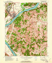 1951 Lawrenceburg1961 Print · USGSLawrenceburg and the Ohio River valley are captured here at mid-century as industrial growth met the rural hills of Kentucky. Genealogists can trace family names through small burial sites like Harrisons Old Home Cem and Graves Cem or locate the historic Bullittsburg Ch.
 - 1954 Map of Lawrenceburg, 1955 Print
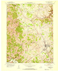 1954 Lawrenceburg1955 Print · USGSMid-century Anderson and Franklin counties center on the railroad hub of Lawrenceburg and the winding Salt River. Genealogists can trace rural life through landmarks like Alton Station, Lanes Mill, and Salt River Ch.2 unique versions available
 - 1954 Map of Tyrone, 1955 Print
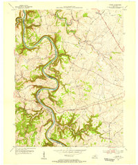 1954 Tyrone1955 Print · USGSThe Kentucky River meanders through Woodford and Anderson counties in the mid-1950s, showing a landscape shaped by water and rail. Trace the historic river crossings and small communities like Tyrone, Milner, and the church at Glenns Creek Ch.
 - 1956 Map of Louisville, 1971 Print
 1956 Louisville1971 Print · USGSThe Ohio River valley and the Kentucky Bluegrass are captured here during a period of rapid mid-century growth and industrial activity. Genealogists and historians can trace rail-centered towns and military land use at Fort Knox and the Jefferson Proving Ground.2 unique versions available
End of results
Showing maps 1-4 of 4
Top cities near Lawrenceburg
- Frankfort historical maps
- Versailles historical maps
- Wilmore historical maps
- Midway historical maps
- Willisburg historical maps
Frequently asked questions
- What are the different types of historical maps available for Lawrenceburg?
- What is the oldest map of Lawrenceburg?
- Where can I purchase historical maps of Lawrenceburg for my home or office?
- Where can I download high-res historical maps of Lawrenceburg?
- Are there historical topographic maps available for Lawrenceburg?
- Is there historical aerial imagery available for Lawrenceburg?
- Where are historical maps of Lawrenceburg sourced from?