1900s (20th Century) Maps of Griderville, Kentucky
Explore 7 historic maps of Griderville from the 1900s (20th Century). These maps offer a rare glimpse into what life looked like during the 1900s — showing old roads, neighborhoods, homes, and landmarks that have changed or disappeared over time.
Whether you're researching your family's past, planning a metal detecting trip, or studying how Griderville's landscape evolved across the 1900s, these high-resolution maps are a powerful tool for exploring the history of this region.
- Focus on a specific era: All maps on this page are from the 1900s, giving you a focused view of this time period.
- See what’s changed: Compare century-old streets, trails, and buildings to today's modern landscape using overlays and satellite layers.
- Research with precision: Use these maps for genealogy, historical research, land use analysis, or educational projects.
- View, download, or print: Maps are fully viewable online in high resolution, and can be downloaded or printed for your own records.
Start exploring Griderville's history through authentic maps from the 1900s. This is your window into the past.
Griderville, KY maps
(7)- 1935 Map of Horse Cave
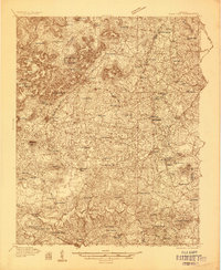 1935 Horse Cave1935 Print · USGSHart and Barren counties in the mid-1930s reveal a landscape shaped by cave tourism and rural education. Genealogists can trace family footprints through dozens of local landmarks like Ragman Seminary, Bunnells Crossing, and New Hope Ch.
 - 1938 Map of Horse Cave
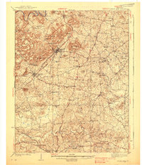 1938 Horse Cave1938 Print · USGSKentucky's cave country thrives in the late 1930s as a hub of early auto tourism and rail commerce. Genealogists can trace family roots through dozen of rural landmarks like Walton Academy, Mammoth Onyx Cave, and the Big Meadow Ch.2 unique versions available
 - 1954 Map of Hiseville, 1956 Print
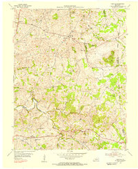 1954 Hiseville1956 Print · USGSBarren and Metcalfe counties come alive in the mid-fifties, showing a landscape of established family farms and small rural crossroads. Researchers can trace ancestral locations near Hiseville, the State Fish Hatchery, and several schools like Dry Hollow Sch.2 unique versions available
 - 1957 Map of Winchester, 1968 Print
 1957 Winchester1968 Print · USGSCentral Kentucky's landscape in the mid-twentieth century features the sprawling Fort Knox and the early parkway system. Genealogists and historians can trace rail lines like the Southern Railway and find landmarks from Bernheim Forest to Pilot Knob.3 unique versions available
 - 1960 Map of Winchester
 1960 Winchester1960 Print · USGSCentral Kentucky's diverse landscape is shown here at mid-century, from the bluegrass plains to the rugged Pottsville Escarpment. Genealogists and historians can trace the rail-and-river network connecting towns like Bardstown and Stanford alongside landmarks like Lake Cumberland.
 - 1973 Map of Hiseville, 1974 Print
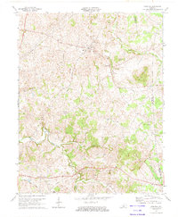 1973 Hiseville1974 Print · USGSThe Barren and Metcalfe county line comes alive in the early seventies, showing a landscape of sinkholes and knobs. Trace family roots at Queens Chapel, Griderville, or the oil-producing fields near Coral Hill.2 unique versions available
 - 1986 Map of Campbellsville
 1986 Campbellsville1986 Print · USGSCentral Kentucky in the mid-eighties was a landscape of deep river valleys and high ridges. Genealogists can trace family holdings near rural settlements like Phillipsburg or locate landmarks such as Mt Gilead Ch and the Magnolia Gas Storage Field.2 unique versions available
End of results
Showing maps 1-7 of 7
Top cities near Griderville
- Glasgow historical maps
- Cave City historical maps
- Horse Cave historical maps
- Edmonton historical maps
- Munfordville historical maps
- Park City historical maps
Frequently asked questions
- What are the different types of historical maps available for Griderville?
- What is the oldest map of Griderville?
- Where can I purchase historical maps of Griderville for my home or office?
- Where can I download high-res historical maps of Griderville?
- Are there historical topographic maps available for Griderville?
- Is there historical aerial imagery available for Griderville?
- Where are historical maps of Griderville sourced from?