1960s Maps of Bourbon County, Kentucky
Explore 6 historic maps of Bourbon County from the 1960s. These maps offer a rare glimpse into what life looked like during the 1960s — showing old roads, neighborhoods, homes, and landmarks that have changed or disappeared over time.
Whether you're researching your family's past, planning a metal detecting trip, or studying how Bourbon County's landscape evolved across the 1960s, these high-resolution maps are a powerful tool for exploring the history of this region.
- Focus on a specific era: All maps on this page are from the 1960s, giving you a focused view of this time period.
- See what’s changed: Compare century-old streets, trails, and buildings to today's modern landscape using overlays and satellite layers.
- Research with precision: Use these maps for genealogy, historical research, land use analysis, or educational projects.
- View, download, or print: Maps are fully viewable online in high resolution, and can be downloaded or printed for your own records.
Start exploring Bourbon County's history through authentic maps from the 1960s. This is your window into the past.
Bourbon County, KY maps
(6)- 1960 Map of Huntington
 1960 Huntington1960 Print · USGSThe tri-state river valley thrived in the late fifties as a hub of heavy industry and Appalachian rail transit. Genealogists and historians can trace the connection between river towns like Ashland and Portsmouth or locate family homesteads near Coleman Ridge.
 - 1964 Map of Louisville
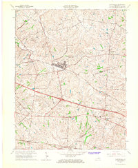
 1964 Louisville1964 Print · USGSThe Ohio River valley and Kentucky Bluegrass are captured in the mid-1960s, showing a region balanced between industrial growth and its agrarian roots. Genealogists and historians can trace the development of county seats like Shelbyville and Paris, or locate established institutions such as Georgetown College and Bernheim Forest.
 - 1965 Map of Austerlitz, 1966 Print
 1965 Austerlitz1966 Print · USGSThe Clark County countryside around Winchester is shown during a period of transition in the mid-sixties as new parkways met historic rail lines. Genealogists and local researchers can trace family lands near Austerlitz, Stony Point, and the Louisville and Nashville railroad.
 - 1965 Map of Sideview, 1966 Print
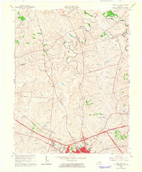
 1965 Sideview1966 Print · USGSThe rural borders of Clark and Bourbon counties are captured here in the mid-1960s, a landscape of winding creeks and historic crossroads. Genealogists and local historians can trace family sites like Prewitt Cem and early settlements including Sideview and Wades Mill.2 unique versions available
 - 1965 Map of Clintonville, 1967 Print
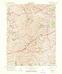
 1965 Clintonville1967 Print · USGSThe Bluegrass region east of Lexington was shaped by military expansion and traditional rail transport in the mid-1960s. Genealogists can locate family landmarks like Bethlehem Ch, the Briar Hill Sch, and settlements at Uttingertown or Chilesburg.3 unique versions available
 - 1965 Map of Lexington East, 1967 Print
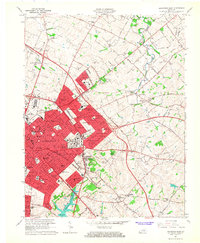 1965 Lexington East1967 Print · USGSLexington and its eastern Fayette County suburbs are captured during a period of significant post-war expansion. Local historians can trace the development of residential areas like Chevy Chase and Idle Hour alongside established landmarks such as Transylvania University and the Bryan Station Spring Cem.6 unique versions available
End of results
Showing maps 1-6 of 6
Top cities of Bourbon County
Frequently asked questions
- What are the different types of historical maps available for Bourbon County?
- What is the oldest map of Bourbon County?
- Where can I purchase historical maps of Bourbon County for my home or office?
- Where can I download high-res historical maps of Bourbon County?
- Are there historical topographic maps available for Bourbon County?
- Is there historical aerial imagery available for Bourbon County?
- Where are historical maps of Bourbon County sourced from?