1950s Maps of Bourbon County, Kentucky
Explore 18 historic maps of Bourbon County from the 1950s. These maps offer a rare glimpse into what life looked like during the 1950s — showing old roads, neighborhoods, homes, and landmarks that have changed or disappeared over time.
Whether you're researching your family's past, planning a metal detecting trip, or studying how Bourbon County's landscape evolved across the 1950s, these high-resolution maps are a powerful tool for exploring the history of this region.
- Focus on a specific era: All maps on this page are from the 1950s, giving you a focused view of this time period.
- See what’s changed: Compare century-old streets, trails, and buildings to today's modern landscape using overlays and satellite layers.
- Research with precision: Use these maps for genealogy, historical research, land use analysis, or educational projects.
- View, download, or print: Maps are fully viewable online in high resolution, and can be downloaded or printed for your own records.
Start exploring Bourbon County's history through authentic maps from the 1950s. This is your window into the past.
Bourbon County, KY maps
(18)- 1950 Map of Lexington East, 1952 Print
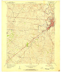
 1950 Lexington East1952 Print · USGSLexington and the surrounding Bluegrass estates are captured at mid-century as the city expanded along the historic pikes and rail lines. Genealogists and historians can locate family landmarks like the Home of Henry Clay, the Horse Cem, and the settlement of Cadentown.
 - 1952 Map of Sharpsburg, 1953 Print
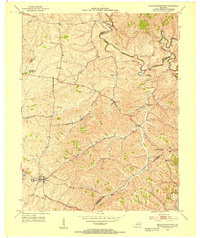
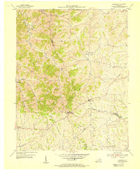
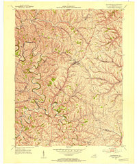 1952 Sharpsburg1953 Print · USGSCentral Kentucky's deeply incised creek valleys and rural crossroads are captured here in the early fifties. Genealogists and local historians can trace family land near Sharpsburg, Springfield Cem, and the meandering banks of Hinkston Creek.
 - 1952 Map of Paris East, 1953 Print
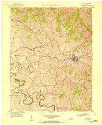
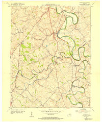
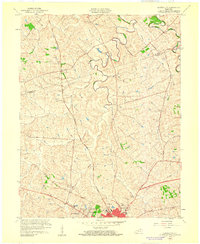
 1952 Paris East1953 Print · USGSBourbon County’s agricultural heartland is documented here in the early fifties, centered on the expansion of Paris and its surrounding countryside. Genealogists and local historians can trace the Louisville and Nashville rail line and locate landmarks like Spears Mill Ch and the Clay Cem.4 unique versions available
 - 1952 Map of Clintonville, 1953 Print
 1952 Clintonville1953 Print · USGSFayette County in the early 1950s is a landscape of established rail lines and significant military activity at the Lexington Signal Depot. Researchers can trace the layout of rural communities like Uttingertown and Old Pine Grove, along with historic sites like Little Zion Ch and Briar Hill Sch.
 - 1952 Map of Austerlitz, 1953 Print
 1952 Austerlitz1953 Print · USGSThe northern outskirts of Winchester and the rural Bourbon-Clark county line are captured here in the early fifties. Genealogists and historians can trace the paths of the Louisville and Nashville railroad and locate landmarks like Thatchers Mill or Pretty Run Sch.
 - 1952 Map of North Middletown, 1953 Print
 1952 North Middletown1953 Print · USGSIn the early fifties, the rolling Bluegrass country around North Middletown remained a landscape of quiet farms and family history. Genealogists can trace family names through landmarks like the Edward Boone Grave, Thomason Cem, and the historic Cane Ridge Meetinghouse.
 - 1952 Map of Sideview, 1954 Print
 1952 Sideview1954 Print · USGSThe rolling hills of Clark and Montgomery counties are captured in the early fifties, showing a rural landscape of tight-knit communities. Family researchers can trace ancestral locations through names like Mason Cem, Sewell Shop, and Wades Mill.
 - 1953 Map of Carlisle, 1954 Print
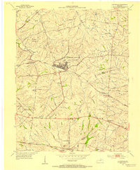
 1953 Carlisle1954 Print · USGSNicholas County and the town of Carlisle are shown in detail during the early 1950s as the rail-and-road network defined local life. Genealogists can locate family landmarks such as Stokes Cem, Oakland Mills Ch, and the Parks Sch.2 unique versions available
 - 1953 Map of Millersburg, 1954 Print
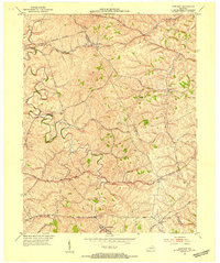
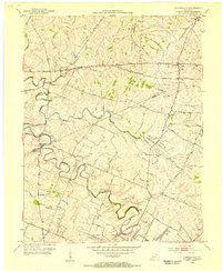
 1953 Millersburg1954 Print · USGSMid-century Bourbon County comes to life as a network of rail-side towns and winding creek valleys. Genealogists can trace family roots at Old Historic Cem, Ruddels Mills, or the campus of the Millersburg Military Institute.2 unique versions available
 - 1954 Map of Lexington East, 1955 Print
 1954 Lexington East1955 Print · USGSMid-century Fayette County comes to life during a period of urban expansion and traditional horse country life. Genealogists and historians can trace institutional roots at Transylvania University or locate family markers at Horse Cem and Howards Grove Cem.
 - 1954 Map of Shawhan, 1955 Print
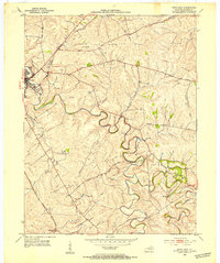
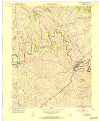
 1954 Shawhan1955 Print · USGSHarrison and Bourbon counties meet in the mid-1950s along a network of winding creeks and early Kentucky roads. Genealogists can trace family footprints at Smith Cem and Ewalt Crossroads or follow the Louisville and Nashville rail line.2 unique versions available
 - 1954 Map of Leesburg, 1955 Print
 1954 Leesburg1955 Print · USGSThe rural borderlands of Harrison, Scott, and Bourbon counties come to life in the mid-1950s. Genealogists and historians can trace family locations near Leesburg and Oxford, or locate community landmarks like Beards Ch and Hinton Cem.3 unique versions available
 - 1954 Map of Paris West, 1955 Print
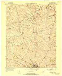
 1954 Paris West1955 Print · USGSThe Bluegrass country of Bourbon County is shown here in the mid-1950s, centered on the growing town of Paris. Genealogists can trace family footprints through rural landmarks like Elizabeth Station, Hopewell Ch, and Mt Olive Cem along the historic rail lines.4 unique versions available
 - 1954 Map of Centerville, 1955 Print
 1954 Centerville1955 Print · USGSMid-century central Kentucky comes alive in this survey of the Bluegrass region at the intersection of Scott, Bourbon, and Fayette counties. Trace the paths of historic hamlets like Newtown and New Zion, or locate the Man-O-War Monument and the old Lemons Mill.4 unique versions available
 - 1956 Map of Louisville, 1971 Print
 1956 Louisville1971 Print · USGSThe Ohio River valley and the Kentucky Bluegrass are captured here during a period of rapid mid-century growth and industrial activity. Genealogists and historians can trace rail-centered towns and military land use at Fort Knox and the Jefferson Proving Ground.2 unique versions available
 - 1957 Map of Huntington, 1966 Print
 1957 Huntington1966 Print · USGSThe industrial heart of the Ohio River valley is captured here in the mid-sixties, showing the growth of Huntington and Ashland. Researchers can trace the extensive rail networks of the Chesapeake and Ohio RR and locate sites like the Chief Cornstalk Hunting Ground.3 unique versions available
 - 1959 Map of Lexington East, 1960 Print
 1959 Lexington East1960 Print · USGSThe Bluegrass heartland around Lexington is shown here just as post-war suburban growth began reshaping the old estate lands. Genealogists and historians can locate family landmarks like the Home of Henry Clay, the Horse Cem at Elmendorf, and the historic Bryan Sta Ch.
 - 1959 Map of Austerlitz, 1960 Print
 1959 Austerlitz1960 Print · USGSThe outskirts of Winchester and the rural reaches of the Bluegrass region are shown here at the end of the fifties. Researchers can find suburban growth in Bel Air, trace the Louisville and Nashville rail line, or locate the Stony Point Ch.
End of results
Showing maps 1-18 of 18
Top cities of Bourbon County
Frequently asked questions
- What are the different types of historical maps available for Bourbon County?
- What is the oldest map of Bourbon County?
- Where can I purchase historical maps of Bourbon County for my home or office?
- Where can I download high-res historical maps of Bourbon County?
- Are there historical topographic maps available for Bourbon County?
- Is there historical aerial imagery available for Bourbon County?
- Where are historical maps of Bourbon County sourced from?