1920s Maps of Bourbon County, Kentucky
Explore 3 historic maps of Bourbon County from the 1920s. These maps offer a rare glimpse into what life looked like during the 1920s — showing old roads, neighborhoods, homes, and landmarks that have changed or disappeared over time.
Whether you're researching your family's past, planning a metal detecting trip, or studying how Bourbon County's landscape evolved across the 1920s, these high-resolution maps are a powerful tool for exploring the history of this region.
- Focus on a specific era: All maps on this page are from the 1920s, giving you a focused view of this time period.
- See what’s changed: Compare century-old streets, trails, and buildings to today's modern landscape using overlays and satellite layers.
- Research with precision: Use these maps for genealogy, historical research, land use analysis, or educational projects.
- View, download, or print: Maps are fully viewable online in high resolution, and can be downloaded or printed for your own records.
Start exploring Bourbon County's history through authentic maps from the 1920s. This is your window into the past.
Bourbon County, KY maps
(3)- 1927 Map of Lexington
 1927 Lexington1927 Print · USGSCentral Kentucky's Bluegrass region in the late twenties was a landscape of influential pikes and rural rail junctions. Genealogists can trace family-named settlements like Mattoxtown and Uttingertown or find local landmarks like Antioch Ch.
 - 1929 Map of Cynthiana
 1929 Cynthiana1929 Print · USGSThe Licking River valley was a busy corridor of rail and river commerce in the late twenties. Genealogists and local historians can trace the foundations of Harrison County through Robinson Sta, Raven Creek Cemetery, and several rural schoolhouses like Keyho Sch.
 - 1929 Map of Lexington
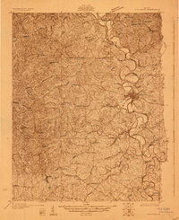
 1929 Lexington1929 Print · USGSThe heart of the Kentucky Bluegrass comes to life in the late twenties, centered on the growing urban hubs of Lexington and Paris. Researchers can locate ancestral crossroads and rural institutions like Russell Cave Sch, Antioch Ch, and the grounds of Elmendorf.2 unique versions available
End of results
Showing maps 1-3 of 3
Top cities of Bourbon County
Frequently asked questions
- What are the different types of historical maps available for Bourbon County?
- What is the oldest map of Bourbon County?
- Where can I purchase historical maps of Bourbon County for my home or office?
- Where can I download high-res historical maps of Bourbon County?
- Are there historical topographic maps available for Bourbon County?
- Is there historical aerial imagery available for Bourbon County?
- Where are historical maps of Bourbon County sourced from?