1927 Map of Lexington
USGS Topo · Published 1927About this map
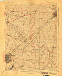
Lexington and Paris anchor this 1927 landscape, revealing the dense network of pikes and rail lines that defined Central Kentucky’s Bluegrass region before modern highway expansion. The map captures a complex social geography of small settlements and neighborhood centers, including New Zion, Jimtown, Mattoxtown, and Uttingertown. These communities, often centered around institutions like Antioch Ch or local schools like Russell Cave Sch, reflect the rural kinship and labor patterns of the early twentieth century.
Find a feature on this map
61 named features on this map. Tap any name to fly to it.
Don’t see what you’re looking for? This feature index may not catch every label — zoom into the map to look around manually.
Map Details
Editions of this 1927 Lexington Map
This is the sole edition of this map. No revisions or reprints were ever made.
Historical Maps of Lexington Through Time
3 maps found