1990s Maps of Axtel, Kentucky
Explore 2 historic maps of Axtel from the 1990s. These maps offer a rare glimpse into what life looked like during the 1990s — showing old roads, neighborhoods, homes, and landmarks that have changed or disappeared over time.
Whether you're researching your family's past, planning a metal detecting trip, or studying how Axtel's landscape evolved across the 1990s, these high-resolution maps are a powerful tool for exploring the history of this region.
- Focus on a specific era: All maps on this page are from the 1990s, giving you a focused view of this time period.
- See what’s changed: Compare century-old streets, trails, and buildings to today's modern landscape using overlays and satellite layers.
- Research with precision: Use these maps for genealogy, historical research, land use analysis, or educational projects.
- View, download, or print: Maps are fully viewable online in high resolution, and can be downloaded or printed for your own records.
Start exploring Axtel's history through authentic maps from the 1990s. This is your window into the past.
Axtel, KY maps
(2)- 1991 Map of Tell City
 1991 Tell City1991 Print · USGSThe Ohio River valley at the start of the nineties reveals a landscape of riverfront industry and sprawling conservation lands. Genealogists can locate family landmarks like Wesley Chapel and rural communities such as Reynolds Station and Maceo.
 - 1993 Map of Kingswood, 1996 Print
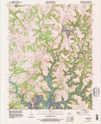 1993 Kingswood1996 Print · USGSBreckinridge County's winding waterways and rural crossroads are captured here in the early nineties. Genealogists and local historians can trace the intricate shoreline of Rough River Lake and locate community landmarks near Kingswood, Westview, and Axtel.
End of results
Showing maps 1-2 of 2
Top cities near Axtel
- Leitchfield historical maps
- Hardinsburg historical maps
- Irvington historical maps
- Cloverport historical maps
- Caneyville historical maps
Frequently asked questions
- What are the different types of historical maps available for Axtel?
- What is the oldest map of Axtel?
- Where can I purchase historical maps of Axtel for my home or office?
- Where can I download high-res historical maps of Axtel?
- Are there historical topographic maps available for Axtel?
- Is there historical aerial imagery available for Axtel?
- Where are historical maps of Axtel sourced from?