1940s Maps of High Plains, Kentucky
Explore 3 historic maps of High Plains from the 1940s. These maps offer a rare glimpse into what life looked like during the 1940s — showing old roads, neighborhoods, homes, and landmarks that have changed or disappeared over time.
Whether you're researching your family's past, planning a metal detecting trip, or studying how High Plains's landscape evolved across the 1940s, these high-resolution maps are a powerful tool for exploring the history of this region.
- Focus on a specific era: All maps on this page are from the 1940s, giving you a focused view of this time period.
- See what’s changed: Compare century-old streets, trails, and buildings to today's modern landscape using overlays and satellite layers.
- Research with precision: Use these maps for genealogy, historical research, land use analysis, or educational projects.
- View, download, or print: Maps are fully viewable online in high resolution, and can be downloaded or printed for your own records.
Start exploring High Plains's history through authentic maps from the 1940s. This is your window into the past.
High Plains, KY maps
(3)- 1941 Map of Ekron
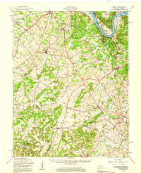
 1941 Ekron1941 Print · USGSNorthern Kentucky and the Ohio River shoreline are captured here in the early 1940s, showing the rural communities of Meade and Hardin Counties. Genealogists can trace family locations near Ekron, Shumate School, and the historic Sherman Landing.
 - 1947 Map of Ekron, 1959 Print
 1947 Ekron1959 Print · USGSMeade County and the riverfronts of the Ohio Valley come alive in this late 1940s survey. Genealogists and historians can trace the foundations of Garnettsville, locate rural landmarks like Doe Run Mill, or search for family connections at Cedar Farm Cem and St Martins Sch.
 - 1948 Map of Big Spring
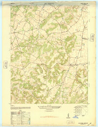 1948 Big Spring1948 Print · USGSKentucky's rural interior comes into focus shortly after the war, showing the tight-knit network of country roads and family-named corners. Genealogists can trace property and community life near Bewleyville School, High Plains, and the prominent Big Spring crossing.
End of results
Showing maps 1-3 of 3
Top cities near High Plains
- Vine Grove historical maps
- Hardinsburg historical maps
- Brandenburg historical maps
- Irvington historical maps
- Ekron historical maps
Frequently asked questions
- What are the different types of historical maps available for High Plains?
- What is the oldest map of High Plains?
- Where can I purchase historical maps of High Plains for my home or office?
- Where can I download high-res historical maps of High Plains?
- Are there historical topographic maps available for High Plains?
- Is there historical aerial imagery available for High Plains?
- Where are historical maps of High Plains sourced from?