1941 Map of Ekron
USGS Topo · Published 1941About this map
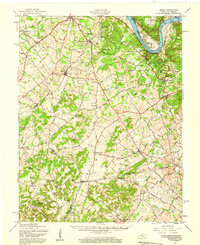
The Ohio River forms the northern boundary of this 1941 tactical survey, winding past a series of historical river points including Pilcher Landing, Cedar Farm Landing, and Sherman Landing. Inland, the terrain of northern Kentucky is defined by the Louisville and Nashville RR, which connects settlements like Ekron, Guston, and Brandenburg Station. This period before major postwar expansion reveals a landscape of rural schoolhouses and country churches, such as Shumate School and New Highland Church, serving scattered farming communities. The presence of the Otter Creek National Park and the Gas Pump Station near Garnettsville suggests a region transitioning between agricultural roots and early twentieth-century infrastructure development. Military influence is also evident, with portions of the map covering areas near the Meade and Hardin County line, including the now-significant site of Stithton.
Find a feature on this map
38 named features on this map. Tap any name to fly to it.
Don’t see what you’re looking for? This feature index may not catch every label — zoom into the map to look around manually.
Map Details
Editions of this 1941 Ekron Map
This is the sole edition of this map. No revisions or reprints were ever made.