1900s (20th Century) Maps of Pottertown, Kentucky
Explore 6 historic maps of Pottertown from the 1900s (20th Century). These maps offer a rare glimpse into what life looked like during the 1900s — showing old roads, neighborhoods, homes, and landmarks that have changed or disappeared over time.
Whether you're researching your family's past, planning a metal detecting trip, or studying how Pottertown's landscape evolved across the 1900s, these high-resolution maps are a powerful tool for exploring the history of this region.
- Focus on a specific era: All maps on this page are from the 1900s, giving you a focused view of this time period.
- See what’s changed: Compare century-old streets, trails, and buildings to today's modern landscape using overlays and satellite layers.
- Research with precision: Use these maps for genealogy, historical research, land use analysis, or educational projects.
- View, download, or print: Maps are fully viewable online in high resolution, and can be downloaded or printed for your own records.
Start exploring Pottertown's history through authentic maps from the 1900s. This is your window into the past.
Pottertown, KY maps
(6)- 1936 Map of New Concord
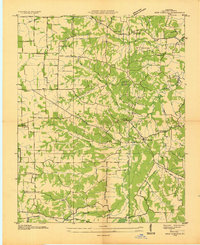 1936 New Concord1936 Print · USGSCalloway County, Kentucky, is shown here in the mid-1930s as a landscape of small family farms and community hubs. Researchers can locate ancestral sites like Sulphur Springs Ch, Nicks Cem, and schools such as Stone Sch.
 - 1942 Map of New Concord
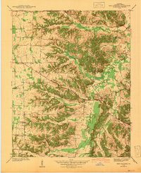 1942 New Concord1942 Print · USGSCalloway County is captured here in the early 1940s, showing a landscape of ridge-top farms and winding creek bottoms before major modern development. Genealogists can trace family roots through numerous small burial grounds like Outland Cem and country landmarks such as Sulphur Sprs Ch or Pottertown.
 - 1955 Map of New Concord, 1956 Print
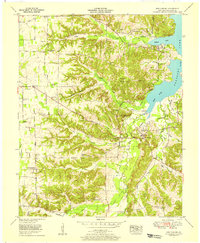 1955 New Concord1956 Print · USGSCalloway County is captured here in the mid-1950s, showing the intersection of rural Kentucky life with the recently formed reservoir shoreline. Genealogists and researchers can trace the settlement at Pottertown and the winding course of the Blood River.4 unique versions available
 - 1955 Map of New Concord, 1957 Print
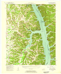 1955 New Concord1957 Print · USGSCalloway County and the Tennessee River valley are shown here just after the mid-century creation of Kentucky Lake. Local historians can trace established rural settlements like New Concord and Hico, alongside landmark sites like Fort Henry and Russell Chapel.
 - 1956 Map of Dyersburg, 1960 Print
 1956 Dyersburg1960 Print · USGSThe Four Rivers region comes alive in the mid-fifties, capturing the intricate borderlands of Tennessee, Kentucky, and Missouri. Genealogists and historians can trace the rail-and-river networks connecting Dyersburg, Caruthersville, and the shoreline of Reelfoot Lake.4 unique versions available
 - 1986 Map of Murray
 1986 Murray1986 Print · USGSWestern Kentucky in the mid-1980s reveals a landscape defined by the Tennessee and Cumberland rivers. Genealogists and historians can trace rail-town development along the Illinois Central Gulf RR and find family-named locations like Dukedom and Water Valley.2 unique versions available
End of results
Showing maps 1-6 of 6
Top cities near Pottertown
- Murray historical maps
- Benton historical maps
- Puryear historical maps
- Hardin historical maps
- Hazel historical maps
Frequently asked questions
- What are the different types of historical maps available for Pottertown?
- What is the oldest map of Pottertown?
- Where can I purchase historical maps of Pottertown for my home or office?
- Where can I download high-res historical maps of Pottertown?
- Are there historical topographic maps available for Pottertown?
- Is there historical aerial imagery available for Pottertown?
- Where are historical maps of Pottertown sourced from?