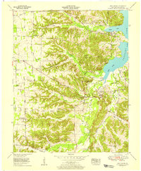
1955 Map of New Concord
USGS Topo · Published 1956About this map
The community of Pottertown sits at the northern edge of this 1955 survey, which documents a landscape transitioning as the Kentucky Lake reservoir impacts the regional geography. The map illustrates the rugged dissected terrain leading down to the Blood River and the expansive shoreline of the lake itself. Topographic details highlight the intricate network of ridges and hollows characteristic of the Calloway County landscape, showing how local roads and small settlements were organized around these natural drainages before further modern development. This edition reflects a specific moment in the mid-1950s when the Tennessee Valley Authority was actively refining its records of the shorelines and land use following the creation of the reservoir.
Find a feature on this map
1 named feature on this map. Tap any name to fly to it.
Don’t see what you’re looking for? This feature index may not catch every label — zoom into the map to look around manually.
Map Details
Editions of this 1955 New Concord Map
4 editions found
Other maps of this area

1936 · Conyersville
USGS Topo · 1:24,000

1936 · Buchanan
USGS Topo · 1:24,000

1936 · Hazel
USGS Topo · 1:24,000

1936 · New Concord
USGS Topo · 1:24,000

1936 · Hamlin
USGS Topo · 1:24,000

1936 · Centerville Landing
USGS Topo · 1:24,000

1936 · Rushing
USGS Topo · 1:24,000

1936 · Dexter
USGS Topo · 1:24,000

1936 · Hico
USGS Topo · 1:24,000

1942 · New Concord
USGS Topo · 1:24,000