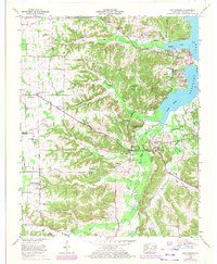
1955 Map of New Concord
USGS Topo · Published 1972About this map
The Blood River flows into the expansive Kentucky Lake in this mid-century portrait of Calloway County. The settlement of New Concord sits at the heart of a landscape defined by its rural social centers, where local life revolved around numerous congregations like Sulphur Springs Church and Macedonia Ch. The mapping reveals a transition in land use, as former wooded areas were recompiled by the Tennessee Valley Authority while traditional family-named landmarks remained prominent. Family historians will find significant value in the distribution of burial grounds, such as Grogane Cem, Outland Cem, and Stubblefield Cem, which are scattered throughout the hollows and ridges. Toward the northwest, Pottertown and New Providence mark the periphery of the agricultural lands, while a prominent lookout tower stands watch over the western high ground.
Find a feature on this map
90 named features on this map. Tap any name to fly to it.
Don’t see what you’re looking for? This feature index may not catch every label — zoom into the map to look around manually.
Map Details
Editions of this 1955 New Concord Map
4 editions found
Other maps of this area

1936 · Conyersville
USGS Topo · 1:24,000

1936 · Buchanan
USGS Topo · 1:24,000

1936 · Hazel
USGS Topo · 1:24,000

1936 · New Concord
USGS Topo · 1:24,000

1936 · Hamlin
USGS Topo · 1:24,000

1936 · Centerville Landing
USGS Topo · 1:24,000

1936 · Rushing
USGS Topo · 1:24,000

1936 · Dexter
USGS Topo · 1:24,000

1936 · Hico
USGS Topo · 1:24,000

1942 · New Concord
USGS Topo · 1:24,000