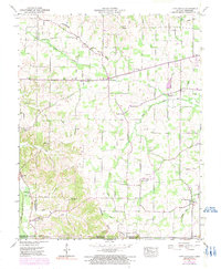
1951 Map of Lynn Grove
USGS Topo · Published 1991About this map
Lynn Grove sits at the heart of this rural landscape where the Tennessee Valley Divide snakes between the headwaters of the Mayfield Creek and the Middle Fork Clarks River. This area, mapped in the early 1950s with revisions from the 1970s, reveals a community structure centered on rural churches and small crossroads settlements like Harris Grove and Wiswell. The terrain is defined by its drainage patterns, with the East Fork Clarks River and Terrapin Creek carving the topography and dictating the placement of early homesteads and cemeteries.
Find a feature on this map
49 named features on this map. Tap any name to fly to it.
Don’t see what you’re looking for? This feature index may not catch every label — zoom into the map to look around manually.
Map Details
Editions of this 1951 Lynn Grove Map
2 editions found
Other maps of this area

1936 · Conyersville
USGS Topo · 1:24,000

1936 · Farmington
USGS Topo · 1:24,000

1936 · Hazel
USGS Topo · 1:24,000

1936 · Crossland
USGS Topo · 1:24,000

1936 · Lynn Grove
USGS Topo · 1:24,000

1936 · Dexter
USGS Topo · 1:24,000

1936 · Kirksey
USGS Topo · 1:24,000

1950 · Puryear
USGS Topo · 1:24,000

1950 · Cottage Grove
USGS Topo · 1:24,000
1951 · Hazel
USGS Topo · 1:24,000