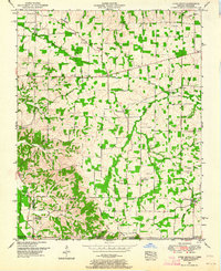
1951 Map of Lynn Grove
USGS Topo · Published 1964About this map
Lynn Grove serves as a central hub for this rural stretch of Calloway County, Kentucky, and Henry County, Tennessee, just after the mid-century. The landscape is defined by the Tennessee Valley Divide, which separates the drainage systems of Mayfield Creek and the Clarks River. This agricultural area is densely populated with community landmarks, particularly country churches like Salem Ch and Sinking Spring Church, alongside numerous family-named cemeteries such as Waterfield Cem and Brush Island Cem.
Find a feature on this map
44 named features on this map. Tap any name to fly to it.
Don’t see what you’re looking for? This feature index may not catch every label — zoom into the map to look around manually.
Map Details
Editions of this 1951 Lynn Grove Map
2 editions found
Other maps of this area

1936 · Conyersville
USGS Topo · 1:24,000

1936 · Farmington
USGS Topo · 1:24,000

1936 · Hazel
USGS Topo · 1:24,000

1936 · Crossland
USGS Topo · 1:24,000

1936 · Lynn Grove
USGS Topo · 1:24,000

1936 · Dexter
USGS Topo · 1:24,000

1936 · Kirksey
USGS Topo · 1:24,000

1950 · Puryear
USGS Topo · 1:24,000

1950 · Cottage Grove
USGS Topo · 1:24,000
1951 · Hazel
USGS Topo · 1:24,000