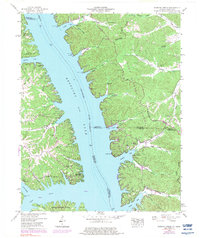
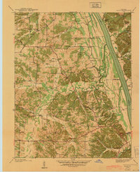
1950 Map of Rushing Creek
USGS Topo · Published 1983About this map
Kentucky Lake dominates this landscape, where the waters of the Tennessee River define the borders of Calloway and Trigg counties. The map captures a transitional moment for the peninsula now known as Land Between the Lakes, showing the complex network of family cemeteries and small settlements that remained after the creation of the reservoir. Notable genealogical sites such as Mays Cem, Lone Oak Cem, and Turkey Creek Cem are scattered across the wooded ridges. The winding route of The Trace provides the primary north-south passage through the interior, connecting remote points like the Lookout tower and the Center Ridge Church. Along the shoreline, recreational development is evident at Kenlake State Park and the Rushing Creek Campground, illustrating the region's shift toward a water-based economy and federal conservation management.
Find a feature on this map
65 named features on this map. Tap any name to fly to it.
Don’t see what you’re looking for? This feature index may not catch every label — zoom into the map to look around manually.
Map Details
Editions of this 1950 Rushing Creek Map
5 editions found

Other maps of this area

1936 · Tharpe
USGS Topo · 1:24,000

1936 · New Concord
USGS Topo · 1:24,000

1936 · Hamlin
USGS Topo · 1:24,000

1936 · Fenton
USGS Topo · 1:24,000

1936 · Hiatt
USGS Topo · 1:24,000

1936 · Golden Pond
USGS Topo · 1:48,000

1936 · Rushing
USGS Topo · 1:24,000

1936 · Hico
USGS Topo · 1:24,000
1940 · Hiatt
USGS Topo · 1:24,000

1942 · New Concord
USGS Topo · 1:24,000