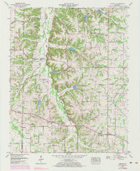
1951 Map of Kirksey
USGS Topo · Published 1983About this map
Clarks River West Fork snakes through this landscape, dividing the rolling terrain of Calloway and Graves Counties. The area is defined by its small agricultural communities and rural infrastructure, from the hilltop village of Kirksey to the historic crossing at Backusburg. The map reveals a dense network of family history markers, including Mt Carmel Church & Cem and dozens of private burial grounds like Collie Cem and Yandell Cem. Industrial remnants such as the Clay Pits near the Marshall County line hint at earlier resource extraction, while the Kirksey Lookout Tower stands as a sentinel over the woodland revisions. This mid-century document captures the region after the establishment of the Tennessee Valley Divide, preserving the locations of country schools and churches like Mt Hebron Church and Goshen Ch before further modernization changed the rural character.
Find a feature on this map
62 named features on this map. Tap any name to fly to it.
Don’t see what you’re looking for? This feature index may not catch every label — zoom into the map to look around manually.
Map Details
Editions of this 1951 Kirksey Map
3 editions found

Other maps of this area

1936 · Farmington
USGS Topo · 1:24,000

1936 · Hazel
USGS Topo · 1:24,000

1936 · Oak Level
USGS Topo · 1:24,000

1936 · Lynn Grove
USGS Topo · 1:24,000

1936 · Hardin
USGS Topo · 1:24,000

1936 · Benton
USGS Topo · 1:48,000

1936 · Westplains
USGS Topo · 1:24,000

1936 · Dexter
USGS Topo · 1:24,000

1936 · Kirksey
USGS Topo · 1:24,000
1951 · Hardin
USGS Topo · 1:24,000