1936 Map of Benton
USGS Topo · Published 1936About this map
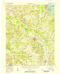
Benton serves as the central hub of Marshall County in this 1936 survey, which captures the region's landscape before the massive changes brought by later industrial and reservoir developments. The East Fork Clarks River winds through the center of the sheet, supported by a network of river crossings including the Bryan Ford Bridge, McCoy Ford Bridge, and Washburn Ford. The map provides significant genealogical value, documenting dozens of family-named burial grounds like Fuchs Cem and Bolton Cem, alongside rural social centers like the Community Chapel and Lone Valley Sch. Of particular note is the presence of C C C Camp No 519 just west of Benton, reflecting the era's Depression-relief efforts. The landscape is dotted with small, named localities such as Briensburg, Brewers, and Hardin, each defined by its local church or schoolhouse.
Find a feature on this map
84 named features on this map. Tap any name to fly to it.
Don’t see what you’re looking for? This feature index may not catch every label — zoom into the map to look around manually.
Map Details
Editions of this 1936 Benton Map
This is the sole edition of this map. No revisions or reprints were ever made.