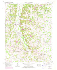
1951 Map of Kirksey
USGS Topo · Published 1972About this map
Clarks River and its West Fork meander through this Calloway County landscape, defining a network of creek-bottoms and ridges just north of the Tennessee Valley Divide. The settlement pattern is anchored by small crossroads such as Kirksey, Backusburg, and Coldwater, each serving as a focal point for the surrounding farming community during the mid-20th century. Local family history is deeply embedded in the land, evidenced by numerous burial grounds like Asbury Cem, Mt Zion Cem, and Bazzell Cem that dot the hillsides.
Find a feature on this map
65 named features on this map. Tap any name to fly to it.
Don’t see what you’re looking for? This feature index may not catch every label — zoom into the map to look around manually.
Map Details
Editions of this 1951 Kirksey Map
3 editions found

Other maps of this area

1936 · Farmington
USGS Topo · 1:24,000

1936 · Hazel
USGS Topo · 1:24,000

1936 · Oak Level
USGS Topo · 1:24,000

1936 · Lynn Grove
USGS Topo · 1:24,000

1936 · Hardin
USGS Topo · 1:24,000

1936 · Benton
USGS Topo · 1:48,000

1936 · Westplains
USGS Topo · 1:24,000

1936 · Dexter
USGS Topo · 1:24,000

1936 · Kirksey
USGS Topo · 1:24,000
1951 · Hardin
USGS Topo · 1:24,000