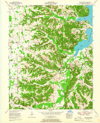
1955 Map of New Concord
USGS Topo · Published 1965About this map
New Concord and the surrounding Calloway County countryside are defined here by the intricate shoreline of Kentucky Lake and the Blood River. This mid-century survey reveals a landscape where old family homesteads and community centers are marked by numerous burial grounds, including Stubblefield Cem, Lawson Cem, and Barnett Cem. The terrain is deeply dissected by drainages such as Wildcat Creek, Goose Creek, and Dog Creek, which create complex ridges and hollows like Culpepper Hollow.
Find a feature on this map
41 named features on this map. Tap any name to fly to it.
Don’t see what you’re looking for? This feature index may not catch every label — zoom into the map to look around manually.
Map Details
Editions of this 1955 New Concord Map
4 editions found
Other maps of this area

1936 · Conyersville
USGS Topo · 1:24,000

1936 · Buchanan
USGS Topo · 1:24,000

1936 · Hazel
USGS Topo · 1:24,000

1936 · New Concord
USGS Topo · 1:24,000

1936 · Hamlin
USGS Topo · 1:24,000

1936 · Centerville Landing
USGS Topo · 1:24,000

1936 · Rushing
USGS Topo · 1:24,000

1936 · Dexter
USGS Topo · 1:24,000

1936 · Hico
USGS Topo · 1:24,000

1942 · New Concord
USGS Topo · 1:24,000