1950s Maps of Forrest Park, Winchester
Explore 3 historic maps of Forrest Park from the 1950s. These maps offer a rare glimpse into what life looked like during the 1950s — showing old roads, neighborhoods, homes, and landmarks that have changed or disappeared over time.
Whether you're researching your family's past, planning a metal detecting trip, or studying how Forrest Park's landscape evolved across the 1950s, these high-resolution maps are a powerful tool for exploring the history of this region.
- Focus on a specific era: All maps on this page are from the 1950s, giving you a focused view of this time period.
- See what’s changed: Compare century-old streets, trails, and buildings to today's modern landscape using overlays and satellite layers.
- Research with precision: Use these maps for genealogy, historical research, land use analysis, or educational projects.
- View, download, or print: Maps are fully viewable online in high resolution, and can be downloaded or printed for your own records.
Start exploring Forrest Park's history through authentic maps from the 1950s. This is your window into the past.
Forrest Park, Winchester maps
(3)- 1952 Map of Austerlitz, 1953 Print
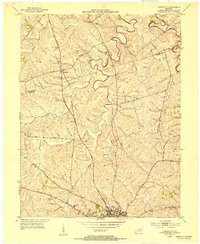 1952 Austerlitz1953 Print · USGSThe northern outskirts of Winchester and the rural Bourbon-Clark county line are captured here in the early fifties. Genealogists and historians can trace the paths of the Louisville and Nashville railroad and locate landmarks like Thatchers Mill or Pretty Run Sch.
 - 1956 Map of Louisville, 1971 Print
 1956 Louisville1971 Print · USGSThe Ohio River valley and the Kentucky Bluegrass are captured here during a period of rapid mid-century growth and industrial activity. Genealogists and historians can trace rail-centered towns and military land use at Fort Knox and the Jefferson Proving Ground.2 unique versions available
 - 1959 Map of Austerlitz, 1960 Print
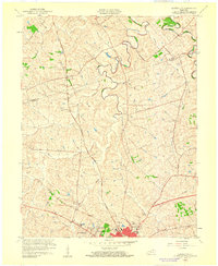 1959 Austerlitz1960 Print · USGSThe outskirts of Winchester and the rural reaches of the Bluegrass region are shown here at the end of the fifties. Researchers can find suburban growth in Bel Air, trace the Louisville and Nashville rail line, or locate the Stony Point Ch.
End of results
Showing maps 1-3 of 3
Top cities near Forrest Park
- Lexington historical maps
- Richmond historical maps
- Winchester historical maps
- Paris historical maps
- Mount Sterling historical maps
- North Middletown historical maps
Frequently asked questions
- What are the different types of historical maps available for Forrest Park?
- What is the oldest map of Forrest Park?
- Where can I purchase historical maps of Forrest Park for my home or office?
- Where can I download high-res historical maps of Forrest Park?
- Are there historical topographic maps available for Forrest Park?
- Is there historical aerial imagery available for Forrest Park?
- Where are historical maps of Forrest Park sourced from?