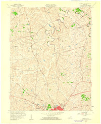
1959 Map of Austerlitz
USGS Topo · Published 1960About this map
The boundary between Bourbon Co and Clark Co bisects this Kentucky landscape, which centers on the northward-flowing currents of Strodes and Stoner creeks. Near the southern edge, the growth of Winchester is evident through residential developments like Victory Heights, Bel Air, and Meadowbrook, while the Central Sch and Victory Heights Sch anchor these mid-century communities. Further north, the smaller settlement of Austerlitz stands at the intersection of Thatchers and Mill roads, representing the more rural character of the Bluegrass region.
Find a feature on this map
28 named features on this map. Tap any name to fly to it.
Don’t see what you’re looking for? This feature index may not catch every label — zoom into the map to look around manually.
Map Details
Editions of this 1959 Austerlitz Map
This is the sole edition of this map. No revisions or reprints were ever made.
Other maps of this area

1892 · Richmond
USGS Topo · 1:125,000

1897 · Richmond
USGS Topo · 1:125,000

1927 · Lexington
USGS Topo · 1:48,000

1929 · Lexington
USGS Topo · 1:62,500

1952 · Paris East
USGS Topo · 1:24,000

1952 · Clintonville
USGS Topo · 1:24,000

1952 · Austerlitz
USGS Topo · 1:24,000

1952 · North Middletown
USGS Topo · 1:24,000

1952 · Ford
USGS Topo · 1:24,000

1952 · Winchester
USGS Topo · 1:24,000