
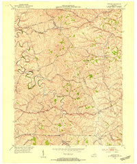
1952 Map of Winchester
USGS Topo · Published 1954About this map
Winchester serves as the bustling urban center of this central Kentucky landscape, anchored by its Courthouse and the local Hospital. The town's mid-century educational footprint is particularly notable, featuring the Julius Rosenwald Sch and Hickman St Sch, alongside several rural schools like Mooresville Sch and Locknane Sch that served outlying farming communities. The infrastructure of the era is defined by the intersection of the Chesapeake and Ohio and Louisville and Nashville railroads, which facilitated regional commerce.
Find a feature on this map
53 named features on this map. Tap any name to fly to it.
Don’t see what you’re looking for? This feature index may not catch every label — zoom into the map to look around manually.
Map Details
Editions of this 1952 Winchester Map
This is the sole edition of this map. No revisions or reprints were ever made.
Other maps of this area

1892 · Richmond
USGS Topo · 1:125,000

1897 · Richmond
USGS Topo · 1:125,000

1927 · Lexington
USGS Topo · 1:48,000

1929 · Lexington
USGS Topo · 1:62,500

1952 · Union City
USGS Topo · 1:24,000

1952 · Palmer
USGS Topo · 1:24,000

1952 · Clintonville
USGS Topo · 1:24,000

1952 · Austerlitz
USGS Topo · 1:24,000

1952 · Ford
USGS Topo · 1:24,000
1952 · Sideview
USGS Topo · 1:24,000