
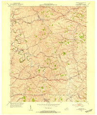
1952 Map of Austerlitz
USGS Topo · Published 1953About this map
Winchester serves as the focal point of this 1952 study, where the northern edge of the city meets a landscape defined by rolling Bluegrass country and early industrial sites. The boundary between Bourbon and Clark Counties bisects the terrain, illustrating a rural economy historically tied to milling and rail transport. Notable landmarks such as Thatchers Mill on Thatchers Mill Road and Donaldson Mill reflect the localized utility of the region's waterways. The Louisville and Nashville railroad cuts a prominent path through the center, passing the settlement of Renick and connecting Austerlitz to the regional hub of Winchester. Local social centers, including Stony Point Ch, Pretty Run Sch, and Victory Heights Sch, are scattered among the drainages of Stoner Creek and Strodes Creek, showing the distribution of small communities before late-twentieth-century expansion.
Find a feature on this map
25 named features on this map. Tap any name to fly to it.
Don’t see what you’re looking for? This feature index may not catch every label — zoom into the map to look around manually.
Map Details
Editions of this 1952 Austerlitz Map
This is the sole edition of this map. No revisions or reprints were ever made.
Other maps of this area

1892 · Richmond
USGS Topo · 1:125,000

1897 · Richmond
USGS Topo · 1:125,000

1927 · Lexington
USGS Topo · 1:48,000

1929 · Lexington
USGS Topo · 1:62,500

1952 · Paris East
USGS Topo · 1:24,000

1952 · Clintonville
USGS Topo · 1:24,000

1952 · North Middletown
USGS Topo · 1:24,000

1952 · Ford
USGS Topo · 1:24,000

1952 · Winchester
USGS Topo · 1:24,000
1952 · Sideview
USGS Topo · 1:24,000