1970s Maps of Clay County, Kentucky
Explore 16 historic maps of Clay County from the 1970s. These maps offer a rare glimpse into what life looked like during the 1970s — showing old roads, neighborhoods, homes, and landmarks that have changed or disappeared over time.
Whether you're researching your family's past, planning a metal detecting trip, or studying how Clay County's landscape evolved across the 1970s, these high-resolution maps are a powerful tool for exploring the history of this region.
- Focus on a specific era: All maps on this page are from the 1970s, giving you a focused view of this time period.
- See what’s changed: Compare century-old streets, trails, and buildings to today's modern landscape using overlays and satellite layers.
- Research with precision: Use these maps for genealogy, historical research, land use analysis, or educational projects.
- View, download, or print: Maps are fully viewable online in high resolution, and can be downloaded or printed for your own records.
Start exploring Clay County's history through authentic maps from the 1970s. This is your window into the past.
Clay County, KY maps
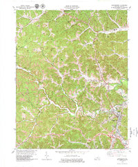
(16)- 1976 Map of Tyner, 1984 Print
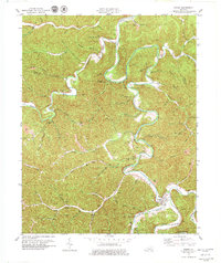
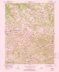 1976 Tyner1984 Print · USGSJackson County and the borders of Clay and Laurel Counties are captured here in the early 1950s. Genealogists can trace family roots through numerous remote burial sites like Walnut Hill Cem and old schoolhouses including Welchburg Sch.
 - 1977 Map of Middlesboro, 1983 Print
 1977 Middlesboro1983 Print · USGSThe tri-state border region of Kentucky, Tennessee, and Virginia is shown here in the late seventies as the rail-and-river economy hummed through the gaps. Trace local family roots and transit routes through Middlesboro, Harlan, and Cumberland Gap National Historical Park.
 - 1977 Map of Hazard, 1983 Print
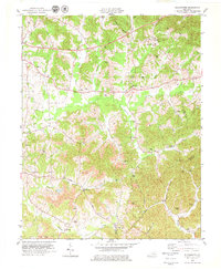
 1977 Hazard1983 Print · USGSEastern Kentucky's coal country comes into sharp focus during the late seventies, showing the deep-set river valleys and mountain gaps that shaped regional life. Genealogists can trace family connections through river-bottom settlements like Oneida, Krypton, and Bulan or follow the Seaboard System rail lines.
 - 1979 Map of Beverly
 1979 Beverly1979 Print · USGSThe headwaters of the Cumberland River meet the coalfields of Bell and Clay counties in the late seventies. Researchers can trace family history at Beverly and Red Bird Settlement Sch or locate landmarks like Cow Fork Ch and the Louisville and Nashville rail line.
 - 1979 Map of Maulden
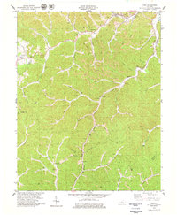
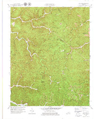
 1979 Maulden1979 Print · USGSClay County and the surrounding ridges are shown in the late seventies as the coal and gas industries reshaped the traditional landscape. Genealogists can locate family burial sites like McDaniel Cem and rural centers like Burning Springs and Little.
 - 1979 Map of Big Creek
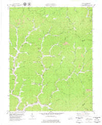
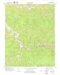 1979 Big Creek1979 Print · USGSClay County and the surrounding coal country are captured here in the late seventies as industrial mining and modern highways reshaped the hills. Local researchers can locate family sites and landmarks near Big Creek, the Daniel Boone Parkway, and the Red Bird River.
 - 1979 Map of Portersburg
 1979 Portersburg1979 Print · USGSEastern Kentucky's coal and timber country is captured here during a period of industrial change in the late seventies. Researchers can trace family sites and vanishing landmarks across Portersburg, Fogertown, and the South Fork Rockcastle River.
 - 1979 Map of Manchester
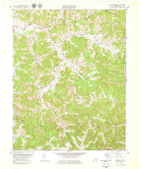
 1979 Manchester1979 Print · USGSManchester and the surrounding Clay County hills are shown during a period of intensive resource extraction in the late seventies. Researchers can trace the coal-and-gas landscape through features like strip mines, the Louisville and Nashville line, and Brown Mission Ch.
 - 1979 Map of Creekville
 1979 Creekville1979 Print · USGSThe Kentucky highlands along the Red Bird River are captured in the late seventies as local industry and mountain life intersected. Genealogists can trace family landmarks and rural institutions including Roark, Flat Creek Sch, and the Holland Cem.
 - 1979 Map of Barcreek
 1979 Barcreek1979 Print · USGSThe rural communities of Clay County appear here in the late seventies as the region balanced traditional life with modern energy and transit. Researchers can trace family roots through settlements like Barcreek, old cemeteries, and landmarks like New Prospect Ch.
 - 1979 Map of Hima
 1979 Hima1979 Print · USGSClay and Knox counties are shown during the height of the coal era in the late seventies. Genealogists can trace family landmarks like Cottongim Cem and rural hubs such as Woollum and the Lilly Grove Ch.
 - 1979 Map of Oneida
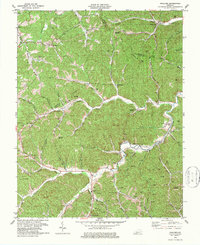
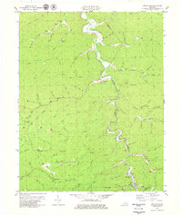
 1979 Oneida1979 Print · USGSThe confluence of Goose Creek and the South Fork Kentucky River defines this Clay County landscape during the late 1970s. Genealogists can locate family landmarks like the Sizemore Cem or Oneida Baptist Institute.
 - 1979 Map of Blackwater
 1979 Blackwater1979 Print · USGSLaurel and Clay counties are shown in the late seventies as the coal industry and mountain roads reshaped the landscape. Trace the path of the Wilderness Road and locate family landmarks like Gregory Cem, Merrimac Ch, and Bush Sch.
 - 1979 Map of Mistletoe
 1979 Mistletoe1979 Print · USGSOwsley County in the late seventies reveals a landscape of isolated creek-side communities like Mistletoe and Sebastian amidst a growing mining industry. Genealogists can locate family landmarks such as the Riley Cem, New Hope Ch, and the Lookout Tower on Cherry Tree Knob.
 - 1979 Map of Scalf
 1979 Scalf1979 Print · USGSKnox County is captured here in the late seventies, showing a landscape defined by coal mining and deep-hollow settlements. Genealogists can trace family names through landmarks like Salt Gum Ch, Dewitt, and several scattered cemeteries along Stinking Creek.
 - 1979 Map of Ogle, 1980 Print
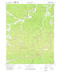
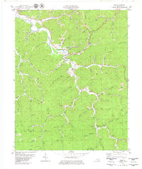 1979 Ogle1980 Print · USGSClay County coal and river life are preserved in this late 1970s survey of the Goose Creek valley. Genealogists and historians can trace family locations near Goose Rock, Brightshade, and Hopewell Ch or follow the path of the L & N RR.
End of results
Showing maps 1-16 of 16
Top cities of Clay County
Frequently asked questions
- What are the different types of historical maps available for Clay County?
- What is the oldest map of Clay County?
- Where can I purchase historical maps of Clay County for my home or office?
- Where can I download high-res historical maps of Clay County?
- Are there historical topographic maps available for Clay County?
- Is there historical aerial imagery available for Clay County?
- Where are historical maps of Clay County sourced from?