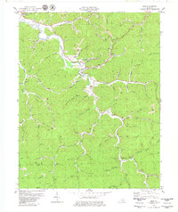
1979 Map of Ogle
USGS Topo · Published 1980About this map
The winding course of Goose Creek and its many tributaries carve through the heart of the Clay County landscape, where the settlement of Goose Rock stands as a central point along the river. This late 1970s topographical survey reveals an economy deeply tied to the land and its resources, evidenced by the L & N RR corridor serving Tipples and numerous Strip Mines scattered across the ridges. Small communities like Garrard, Botto, and Ogle are connected by narrow roads following the creek beds, punctuated by landmarks such as Goose Rock Sch and the Sky Airport. Local social history is etched into the terrain through various hilltop family burial grounds like White Cem and country sanctuaries including Hopewell Ch and Swafford Ch. The map also details a significant Pipeline cutting across the county line into Knox County, reflecting the industrial infrastructure of the era.
Find a feature on this map
100 named features on this map. Tap any name to fly to it.
Don’t see what you’re looking for? This feature index may not catch every label — zoom into the map to look around manually.
Map Details
Editions of this 1979 Ogle Map
This is the sole edition of this map. No revisions or reprints were ever made.
Other maps of this area

1886 · Cumberland Gap
USGS Topo · 1:125,000

1888 · Cumberland Gap
USGS Topo · 1:125,000

1891 · Manchester
USGS Topo · 1:125,000

1891 · Cumberland Gap
USGS Topo · 1:125,000

1903 · Pineville
USGS Topo · 1:48,000

1952 · Hima
USGS Topo · 1:24,000

1952 · Fount
USGS Topo · 1:24,000

1952 · Manchester
USGS Topo · 1:24,000

1953 · Big Creek
USGS Topo · 1:24,000

1954 · Barcreek
USGS Topo · 1:24,000