1990s Maps of East McDowell, Kentucky
Explore 1 historic maps of East McDowell from the 1990s. These maps offer a rare glimpse into what life looked like during the 1990s — showing old roads, neighborhoods, homes, and landmarks that have changed or disappeared over time.
Whether you're researching your family's past, planning a metal detecting trip, or studying how East McDowell's landscape evolved across the 1990s, these high-resolution maps are a powerful tool for exploring the history of this region.
- Focus on a specific era: All maps on this page are from the 1990s, giving you a focused view of this time period.
- See what’s changed: Compare century-old streets, trails, and buildings to today's modern landscape using overlays and satellite layers.
- Research with precision: Use these maps for genealogy, historical research, land use analysis, or educational projects.
- View, download, or print: Maps are fully viewable online in high resolution, and can be downloaded or printed for your own records.
Start exploring East McDowell's history through authentic maps from the 1990s. This is your window into the past.
East McDowell, KY maps
(1)- 1992 Map of Mc Dowell
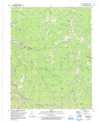 1992 Mc Dowell1992 Print · USGSThe coal country of Floyd County comes into focus in the early 1990s, showing the deep connection between the winding hollows and the regional mining economy. Researchers can trace local genealogy and industry through labels for Grethel PO, the Little Nancy Sch, and the CSX Transportation railroad.
End of results
Showing maps 1-1 of 1
Top cities near East McDowell
- Pikeville historical maps
- Prestonsburg historical maps
- Coal Run Village historical maps
- Wheelwright historical maps
- Betsy Layne historical maps
- Martin historical maps
See more
Frequently asked questions
- What are the different types of historical maps available for East McDowell?
- What is the oldest map of East McDowell?
- Where can I purchase historical maps of East McDowell for my home or office?
- Where can I download high-res historical maps of East McDowell?
- Are there historical topographic maps available for East McDowell?
- Is there historical aerial imagery available for East McDowell?
- Where are historical maps of East McDowell sourced from?