1990s Maps of Prestonsburg, Kentucky
Explore 3 historic maps of Prestonsburg from the 1990s. These maps offer a rare glimpse into what life looked like during the 1990s — showing old roads, neighborhoods, homes, and landmarks that have changed or disappeared over time.
Whether you're researching your family's past, planning a metal detecting trip, or studying how Prestonsburg's landscape evolved across the 1990s, these high-resolution maps are a powerful tool for exploring the history of this region.
- Focus on a specific era: All maps on this page are from the 1990s, giving you a focused view of this time period.
- See what’s changed: Compare century-old streets, trails, and buildings to today's modern landscape using overlays and satellite layers.
- Research with precision: Use these maps for genealogy, historical research, land use analysis, or educational projects.
- View, download, or print: Maps are fully viewable online in high resolution, and can be downloaded or printed for your own records.
Start exploring Prestonsburg's history through authentic maps from the 1990s. This is your window into the past.
Prestonsburg, KY maps
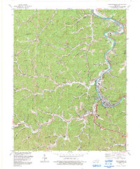
(3)- 1992 Map of Lancer
 1992 Lancer1992 Print · USGSFloyd County during the early nineties shows a landscape defined by the winding waters of Dewey Lake and the active Levisa Fork river valley. Researchers can trace family sites at Mayo Cem and The Old Log Ch or locate old rail stops along the CSX Transportation line.
 - 1992 Map of Prestonsburg
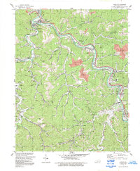
 1992 Prestonsburg1992 Print · USGSThe Levisa Fork valley in the early nineties shows a coal-country landscape balancing industrial roots with new civic growth. Genealogists and researchers can trace family landmarks and mountain hollows from East Point to Bonanza, including Clark Sch and the Drive-in Theater.
 - 1992 Map of Harold
 1992 Harold1992 Print · USGSFloyd County's industrial and community landscape is captured here in the early nineties as the coal and rail economy shaped the valley. Genealogists and historians can trace family locations from Betsy Layne and Harold to smaller settlements like Blue Moon and Printer.
End of results
Showing maps 1-3 of 3
Top cities near Prestonsburg
- Pikeville historical maps
- Paintsville historical maps
- Coal Run Village historical maps
- Van Lear historical maps
- West Van Lear historical maps
- Auxier historical maps
See more
Top neighborhoods of Prestonsburg
Frequently asked questions
- What are the different types of historical maps available for Prestonsburg?
- What is the oldest map of Prestonsburg?
- Where can I purchase historical maps of Prestonsburg for my home or office?
- Where can I download high-res historical maps of Prestonsburg?
- Are there historical topographic maps available for Prestonsburg?
- Is there historical aerial imagery available for Prestonsburg?
- Where are historical maps of Prestonsburg sourced from?