Old Maps of Franklin County, Kentucky for Genealogy
Trace your family roots with 89 historic maps of Franklin County. These high-res maps reveal old neighborhoods, homesites, landmarks, and streets — helping you uncover where your ancestors lived and how the area evolved over time.
- Explore historic neighborhoods: Identify where your relatives may have lived in the 1800s or 1900s.
- Compare maps over time: Trace the changes in streets, buildings, and landmarks for multi-generational research.
- Perfect for genealogy & ancestry research: Used by family historians and researchers to map out lineage and migration.
These maps are an incredible resource for exploring your personal connection to Franklin County's past.
Franklin County, KY maps
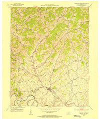
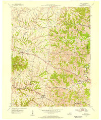
(89)- 1906 Map of Lockport
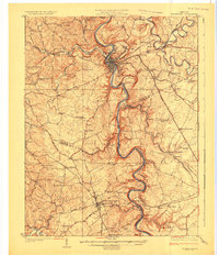
 1906 Lockport1906 Print · USGSOwen and Franklin Counties are surveyed here during the first decade of the century, following the dramatic bends of the Kentucky River. Researchers can trace the river-based economy through Lock & Dam No 1 and old crossings like Manfords Ferry.2 unique versions available
 - 1906 Map of Georgetown, 1954 Print
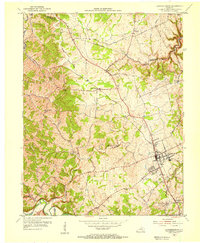
 1906 Georgetown1954 Print · USGSCentral Kentucky at the opening of the twentieth century was a landscape shaped by winding creeks and a dense web of steam rail lines. Local researchers can trace the historic rail corridors of the Southern R R and find early settlements like Paynes Depot and Great Crossing.
 - 1908 Map of Lockport
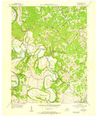
 1908 Lockport1908 Print · USGSLife along the Kentucky River in the early twentieth century centered on the water and the rich flats of the river bottoms. Genealogists can trace family footprints through numerous river crossings like Harpers Ferry and rural landmarks such as Tackitts Mill or the Falling Rock School.3 unique versions available
 - 1908 Map of Georgetown
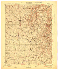
 1908 Georgetown1908 Print · USGSCentral Kentucky at the turn of the century reveals a landscape of thriving rail depots and historic turnpikes connecting major county seats. Genealogists and historians can trace the early footprints of Midway, Donerail, and Great Crossing along the winding North Elkhorn Creek.2 unique versions available
 - 1922 Map of Frankfort
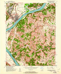
 1922 Frankfort1922 Print · USGSCentral Kentucky's river valleys and rolling uplands are captured here in the early twenties, showing a landscape defined by water and rail. Trace family history at Lanes Mill Fox Gap School or follow the river to Youngs High Bridge and Shryocks Ferry.
 - 1923 Map of Waddy
 1923 Waddy1923 Print · USGSShelby County and Anderson County are captured here in the early 1920s, showing a rural landscape organized around the Midland Trail and regional rail lines. Genealogists can trace family connections to numerous landmarks like Buffalo Lick Church, Jeptha Knob, and small settlements including Waddy and Glensboro.
 - 1924 Map of Frankfort
 1924 Frankfort1924 Print · USGSThe Kentucky River valley and surrounding Bluegrass uplands are documented here during the mid-1920s. Genealogists and researchers can trace rural life through dozens of named district schools and river landmarks like Youngs High Bridge, Lanes Mill, and Shryocks Ferry.2 unique versions available
 - 1925 Map of Mount Eden
 1925 Mount Eden1925 Print · USGSThe rolling hills between Shelbyville and the Salt River are captured here in the mid-twenties, showing a landscape tied to the rails and old turnpikes. Researchers can find dozens of rural landmarks, from Jeptha Knob to family-named sites like Martin School and Browns Store.
 - 1927 Map of Mount Eden
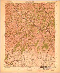
 1927 Mount Eden1927 Print · USGSShelby County and its neighbors at the height of the 1920s reveal a landscape of ridge-top schools and bustling rail towns. Genealogists and local historians can trace family locations near landmarks like Jeptha Knob, the Buffalo Lick Church, or the community of Mount Eden.
 - 1928 Map of New Castle
 1928 New Castle1928 Print · USGSThe rolling uplands of Henry and Shelby County appear here in the late 1920s, just as the regional rail and pike network reached its peak. Genealogists can trace a remarkable number of family-named landmarks and rural institutions, from Sewell Sch to the Indian Fork Ch.
 - 1932 Map of New Castle
 1932 New Castle1932 Print · USGSHenry and Shelby Counties are captured here between the world wars as the rail and river economy thrived. Genealogists can trace family landmarks and rural schoolhouses like Hill Spring Sch, Burks Branch Sch, and the stop at Bellview Hill Spring Sta.
 - 1939 Map of Sadieville
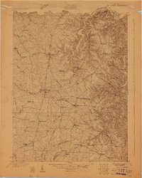
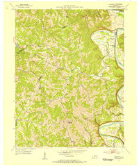
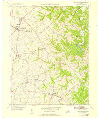
 1939 Sadieville1939 Print · USGSScott and Owen Counties are captured in the late 1930s as agricultural life centered on the Southern Railway and a dense network of country schools. Genealogists can locate family landmarks like Stamping Ground, Burroak Sch, and the Pleasant Hill Ch.2 unique versions available
 - 1951 Map of Lawrenceburg, 1961 Print
 1951 Lawrenceburg1961 Print · USGSLawrenceburg and the Ohio River valley are captured here at mid-century as industrial growth met the rural hills of Kentucky. Genealogists can trace family names through small burial sites like Harrisons Old Home Cem and Graves Cem or locate the historic Bullittsburg Ch.
 - 1952 Map of Midway, 1955 Print
 1952 Midway1955 Print · USGSMidway and the surrounding Bluegrass countryside are captured here in the early fifties as the Louisville and Nashville rail line still pulsed through the town center. Researchers can trace the exact locations of Spring Station, the Orphans Sch, and St Francis Mission amidst the winding creeks.
 - 1953 Map of Frankfort West, 1955 Print
 1953 Frankfort West1955 Print · USGSThe Kentucky state capital and its western hills are captured in the early 1950s, showing the intersection of river transport and rail development. Genealogists and historians can trace family roots through landmarks like Mt Zion Ch, the Stewart Home, and the village of Bridgeport.
 - 1953 Map of Polsgrove, 1955 Print
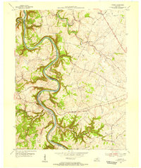
 1953 Polsgrove1955 Print · USGSNorthern Kentucky's river valleys and ridge-top settlements are meticulously detailed in this early 1950s survey. Researchers can trace family roots at Harpers Ferry, locate the Bald Knob High Sch, and find local landmarks like Ottusville or Mt Carmel Ch.4 unique versions available
 - 1953 Map of Stamping Ground, 1955 Print
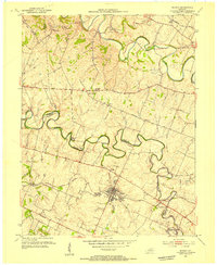
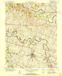
 1953 Stamping Ground1955 Print · USGSThe rural landscape of Scott and Owen counties in the early fifties is defined by small crossroads hamlets and the path of the Frankfort and Cincinnati railroad. Genealogists can trace family footprints through several local burial sites including Minorsville Cem, Riddle Cem, and Cedar Grove Cem.3 unique versions available
 - 1953 Map of Frankfort East, 1955 Print
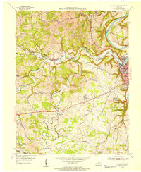
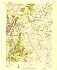 1953 Frankfort East1955 Print · USGSFrankfort and the surrounding bluegrass country are shown in the early fifties as the capital city expanded eastward into the river bluffs. Researchers can locate vanished landmarks like the State Training Home Farm and trace historic routes through Slickway, Stedmantown, and Duckers.
 - 1954 Map of Lawrenceburg, 1955 Print
 1954 Lawrenceburg1955 Print · USGSMid-century Anderson and Franklin counties center on the railroad hub of Lawrenceburg and the winding Salt River. Genealogists can trace rural life through landmarks like Alton Station, Lanes Mill, and Salt River Ch.2 unique versions available
 - 1954 Map of Midway, 1955 Print
 1954 Midway1955 Print · USGSMid-century Woodford and Scott Counties are captured here as a landscape of rail-connected towns and winding creek valleys. Genealogists and researchers can trace local landmarks like the Orphans Sch, the St Francis Mission, and the crossroads at White Sulphur.4 unique versions available
 - 1954 Map of Waddy, 1955 Print
 1954 Waddy1955 Print · USGSShelby and Franklin counties are shown here in the mid-fifties, dominated by the high ground of Jeptha Knob. Genealogists and historians can trace the rural communities of Clay Village, Peytona, and Waddy, as well as the Buffalo Lick Ch.
 - 1954 Map of Switzer, 1955 Print
 1954 Switzer1955 Print · USGSThe river valleys of Franklin and Owen Counties appear in detail during the mid-fifties as the landscape transitions from the Kentucky River to Elkhorn Creek. Researchers can trace rural community centers like Peaks Mill and Elmville, or locate family landmarks such as Tacketts Mill and Carr Cem.4 unique versions available
 - 1954 Map of Tyrone, 1955 Print
 1954 Tyrone1955 Print · USGSThe Kentucky River meanders through Woodford and Anderson counties in the mid-1950s, showing a landscape shaped by water and rail. Trace the historic river crossings and small communities like Tyrone, Milner, and the church at Glenns Creek Ch.
 - 1954 Map of North Pleasureville, 1955 Print
 1954 North Pleasureville1955 Print · USGSThe rural border of Shelby and Henry counties comes alive in the mid-1950s as the rail line connects small agricultural hubs. Genealogists can trace family names at Old Christianburg, Bagdad, and the Consolidated High Sch near North Pleasureville.3 unique versions available
 - 1956 Map of Louisville, 1971 Print
 1956 Louisville1971 Print · USGSThe Ohio River valley and the Kentucky Bluegrass are captured here during a period of rapid mid-century growth and industrial activity. Genealogists and historians can trace rail-centered towns and military land use at Fort Knox and the Jefferson Proving Ground.2 unique versions available
Showing maps 1-25 of 89
Top cities of Franklin County
Frequently asked questions
- What are the different types of historical maps available for Franklin County?
- What is the oldest map of Franklin County?
- Where can I purchase historical maps of Franklin County for my home or office?
- Where can I download high-res historical maps of Franklin County?
- Are there historical topographic maps available for Franklin County?
- Is there historical aerial imagery available for Franklin County?
- Where are historical maps of Franklin County sourced from?