1920s Maps of Franklin County, Kentucky
Explore 6 historic maps of Franklin County from the 1920s. These maps offer a rare glimpse into what life looked like during the 1920s — showing old roads, neighborhoods, homes, and landmarks that have changed or disappeared over time.
Whether you're researching your family's past, planning a metal detecting trip, or studying how Franklin County's landscape evolved across the 1920s, these high-resolution maps are a powerful tool for exploring the history of this region.
- Focus on a specific era: All maps on this page are from the 1920s, giving you a focused view of this time period.
- See what’s changed: Compare century-old streets, trails, and buildings to today's modern landscape using overlays and satellite layers.
- Research with precision: Use these maps for genealogy, historical research, land use analysis, or educational projects.
- View, download, or print: Maps are fully viewable online in high resolution, and can be downloaded or printed for your own records.
Start exploring Franklin County's history through authentic maps from the 1920s. This is your window into the past.
Franklin County, KY maps
(6)- 1922 Map of Frankfort
 1922 Frankfort1922 Print · USGSCentral Kentucky's river valleys and rolling uplands are captured here in the early twenties, showing a landscape defined by water and rail. Trace family history at Lanes Mill Fox Gap School or follow the river to Youngs High Bridge and Shryocks Ferry.
 - 1923 Map of Waddy
 1923 Waddy1923 Print · USGSShelby County and Anderson County are captured here in the early 1920s, showing a rural landscape organized around the Midland Trail and regional rail lines. Genealogists can trace family connections to numerous landmarks like Buffalo Lick Church, Jeptha Knob, and small settlements including Waddy and Glensboro.
 - 1924 Map of Frankfort
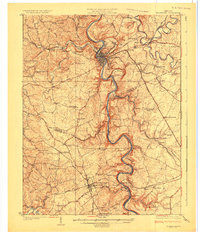 1924 Frankfort1924 Print · USGSThe Kentucky River valley and surrounding Bluegrass uplands are documented here during the mid-1920s. Genealogists and researchers can trace rural life through dozens of named district schools and river landmarks like Youngs High Bridge, Lanes Mill, and Shryocks Ferry.2 unique versions available
 - 1925 Map of Mount Eden
 1925 Mount Eden1925 Print · USGSThe rolling hills between Shelbyville and the Salt River are captured here in the mid-twenties, showing a landscape tied to the rails and old turnpikes. Researchers can find dozens of rural landmarks, from Jeptha Knob to family-named sites like Martin School and Browns Store.
 - 1927 Map of Mount Eden
 1927 Mount Eden1927 Print · USGSShelby County and its neighbors at the height of the 1920s reveal a landscape of ridge-top schools and bustling rail towns. Genealogists and local historians can trace family locations near landmarks like Jeptha Knob, the Buffalo Lick Church, or the community of Mount Eden.
 - 1928 Map of New Castle
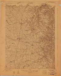 1928 New Castle1928 Print · USGSThe rolling uplands of Henry and Shelby County appear here in the late 1920s, just as the regional rail and pike network reached its peak. Genealogists can trace a remarkable number of family-named landmarks and rural institutions, from Sewell Sch to the Indian Fork Ch.
End of results
Showing maps 1-6 of 6
Top cities of Franklin County
Frequently asked questions
- What are the different types of historical maps available for Franklin County?
- What is the oldest map of Franklin County?
- Where can I purchase historical maps of Franklin County for my home or office?
- Where can I download high-res historical maps of Franklin County?
- Are there historical topographic maps available for Franklin County?
- Is there historical aerial imagery available for Franklin County?
- Where are historical maps of Franklin County sourced from?