1950s Maps of Franklin County, Kentucky
Explore 15 historic maps of Franklin County from the 1950s. These maps offer a rare glimpse into what life looked like during the 1950s — showing old roads, neighborhoods, homes, and landmarks that have changed or disappeared over time.
Whether you're researching your family's past, planning a metal detecting trip, or studying how Franklin County's landscape evolved across the 1950s, these high-resolution maps are a powerful tool for exploring the history of this region.
- Focus on a specific era: All maps on this page are from the 1950s, giving you a focused view of this time period.
- See what’s changed: Compare century-old streets, trails, and buildings to today's modern landscape using overlays and satellite layers.
- Research with precision: Use these maps for genealogy, historical research, land use analysis, or educational projects.
- View, download, or print: Maps are fully viewable online in high resolution, and can be downloaded or printed for your own records.
Start exploring Franklin County's history through authentic maps from the 1950s. This is your window into the past.
Franklin County, KY maps
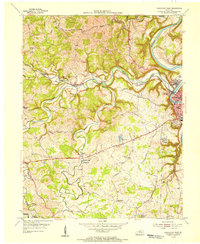
(15)- 1951 Map of Lawrenceburg, 1961 Print
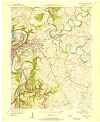
 1951 Lawrenceburg1961 Print · USGSLawrenceburg and the Ohio River valley are captured here at mid-century as industrial growth met the rural hills of Kentucky. Genealogists can trace family names through small burial sites like Harrisons Old Home Cem and Graves Cem or locate the historic Bullittsburg Ch.
 - 1952 Map of Midway, 1955 Print
 1952 Midway1955 Print · USGSMidway and the surrounding Bluegrass countryside are captured here in the early fifties as the Louisville and Nashville rail line still pulsed through the town center. Researchers can trace the exact locations of Spring Station, the Orphans Sch, and St Francis Mission amidst the winding creeks.
 - 1953 Map of Frankfort West, 1955 Print
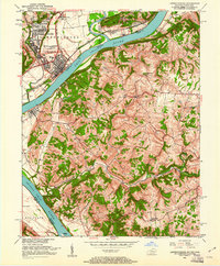
 1953 Frankfort West1955 Print · USGSThe Kentucky state capital and its western hills are captured in the early 1950s, showing the intersection of river transport and rail development. Genealogists and historians can trace family roots through landmarks like Mt Zion Ch, the Stewart Home, and the village of Bridgeport.
 - 1953 Map of Polsgrove, 1955 Print
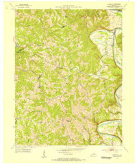 1953 Polsgrove1955 Print · USGSNorthern Kentucky's river valleys and ridge-top settlements are meticulously detailed in this early 1950s survey. Researchers can trace family roots at Harpers Ferry, locate the Bald Knob High Sch, and find local landmarks like Ottusville or Mt Carmel Ch.4 unique versions available
 - 1953 Map of Stamping Ground, 1955 Print
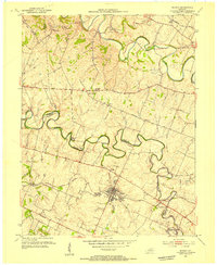
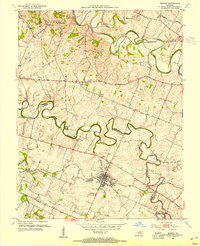
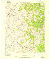
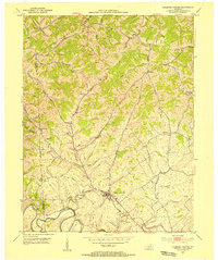 1953 Stamping Ground1955 Print · USGSThe rural landscape of Scott and Owen counties in the early fifties is defined by small crossroads hamlets and the path of the Frankfort and Cincinnati railroad. Genealogists can trace family footprints through several local burial sites including Minorsville Cem, Riddle Cem, and Cedar Grove Cem.3 unique versions available
 - 1953 Map of Frankfort East, 1955 Print
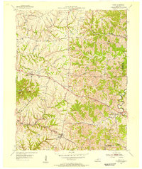
 1953 Frankfort East1955 Print · USGSFrankfort and the surrounding bluegrass country are shown in the early fifties as the capital city expanded eastward into the river bluffs. Researchers can locate vanished landmarks like the State Training Home Farm and trace historic routes through Slickway, Stedmantown, and Duckers.
 - 1954 Map of Lawrenceburg, 1955 Print
 1954 Lawrenceburg1955 Print · USGSMid-century Anderson and Franklin counties center on the railroad hub of Lawrenceburg and the winding Salt River. Genealogists can trace rural life through landmarks like Alton Station, Lanes Mill, and Salt River Ch.2 unique versions available
 - 1954 Map of Midway, 1955 Print
 1954 Midway1955 Print · USGSMid-century Woodford and Scott Counties are captured here as a landscape of rail-connected towns and winding creek valleys. Genealogists and researchers can trace local landmarks like the Orphans Sch, the St Francis Mission, and the crossroads at White Sulphur.4 unique versions available
 - 1954 Map of Waddy, 1955 Print
 1954 Waddy1955 Print · USGSShelby and Franklin counties are shown here in the mid-fifties, dominated by the high ground of Jeptha Knob. Genealogists and historians can trace the rural communities of Clay Village, Peytona, and Waddy, as well as the Buffalo Lick Ch.
 - 1954 Map of Switzer, 1955 Print
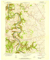
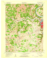
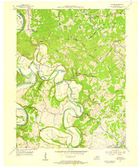 1954 Switzer1955 Print · USGSThe river valleys of Franklin and Owen Counties appear in detail during the mid-fifties as the landscape transitions from the Kentucky River to Elkhorn Creek. Researchers can trace rural community centers like Peaks Mill and Elmville, or locate family landmarks such as Tacketts Mill and Carr Cem.4 unique versions available
 - 1954 Map of Tyrone, 1955 Print
 1954 Tyrone1955 Print · USGSThe Kentucky River meanders through Woodford and Anderson counties in the mid-1950s, showing a landscape shaped by water and rail. Trace the historic river crossings and small communities like Tyrone, Milner, and the church at Glenns Creek Ch.
 - 1954 Map of North Pleasureville, 1955 Print
 1954 North Pleasureville1955 Print · USGSThe rural border of Shelby and Henry counties comes alive in the mid-1950s as the rail line connects small agricultural hubs. Genealogists can trace family names at Old Christianburg, Bagdad, and the Consolidated High Sch near North Pleasureville.3 unique versions available
 - 1956 Map of Louisville, 1971 Print
 1956 Louisville1971 Print · USGSThe Ohio River valley and the Kentucky Bluegrass are captured here during a period of rapid mid-century growth and industrial activity. Genealogists and historians can trace rail-centered towns and military land use at Fort Knox and the Jefferson Proving Ground.2 unique versions available
 - 1959 Map of Frankfort East, 1960 Print
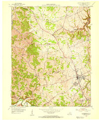
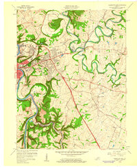 1959 Frankfort East1960 Print · USGSThe Kentucky state capital and its rolling eastern environs are captured here during the growth of the late fifties. Genealogists and local historians can trace suburban development and rural outposts like Stedmantown, Forks of Elkhorn, and Duckers.2 unique versions available
 - 1959 Map of Frankfort West, 1960 Print
 1959 Frankfort West1960 Print · USGSFrankfort and the Kentucky River valley are shown here just as the capital's postwar suburbs were expanding into the surrounding hills. Researchers can trace historic family routes along Old Harrodsburg Road and identify local landmarks like Bridgeport, the Stewart Home, and Mt Zion Ch.2 unique versions available
End of results
Showing maps 1-15 of 15
Top cities of Franklin County
Frequently asked questions
- What are the different types of historical maps available for Franklin County?
- What is the oldest map of Franklin County?
- Where can I purchase historical maps of Franklin County for my home or office?
- Where can I download high-res historical maps of Franklin County?
- Are there historical topographic maps available for Franklin County?
- Is there historical aerial imagery available for Franklin County?
- Where are historical maps of Franklin County sourced from?