1900s (20th Century) Maps of Boydsville, Kentucky
Explore 5 historic maps of Boydsville from the 1900s (20th Century). These maps offer a rare glimpse into what life looked like during the 1900s — showing old roads, neighborhoods, homes, and landmarks that have changed or disappeared over time.
Whether you're researching your family's past, planning a metal detecting trip, or studying how Boydsville's landscape evolved across the 1900s, these high-resolution maps are a powerful tool for exploring the history of this region.
- Focus on a specific era: All maps on this page are from the 1900s, giving you a focused view of this time period.
- See what’s changed: Compare century-old streets, trails, and buildings to today's modern landscape using overlays and satellite layers.
- Research with precision: Use these maps for genealogy, historical research, land use analysis, or educational projects.
- View, download, or print: Maps are fully viewable online in high resolution, and can be downloaded or printed for your own records.
Start exploring Boydsville's history through authentic maps from the 1900s. This is your window into the past.
Boydsville, KY maps
(5)- 1952 Map of Mayfield, 1957 Print
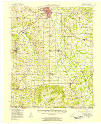 1952 Mayfield1957 Print · USGSGraves County, Kentucky, was a bustling network of rail-side towns and rural parishes at the mid-century. Researchers can trace family history through dozens of landmarks like Rozzell Cem, follow the Illinois Central Railroad, or locate the County Farm.
 - 1952 Map of Lynnville, 1973 Print
 1952 Lynnville1973 Print · USGSSouthern Graves County and the Tennessee borderlands are captured in the early fifties, showing a landscape defined by small farming hamlets and family homesteads. Genealogists can trace rural lifelines through sites like Burnett Chapel, Cuba High Sch, and dozens of burial grounds like Tibbs Cem.
 - 1956 Map of Dyersburg, 1960 Print
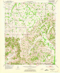
 1956 Dyersburg1960 Print · USGSThe Four Rivers region comes alive in the mid-fifties, capturing the intricate borderlands of Tennessee, Kentucky, and Missouri. Genealogists and historians can trace the rail-and-river networks connecting Dyersburg, Caruthersville, and the shoreline of Reelfoot Lake.4 unique versions available
 - 1978 Map of Lynnville
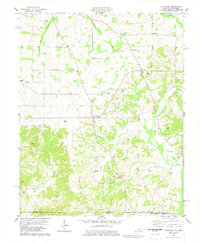 1978 Lynnville1978 Print · USGSThe Kentucky-Tennessee borderlands in the late seventies reveal a landscape of tight-knit rural communities and family legacies. Genealogists can trace ancestral sites at Kesterson Cem, Pittman Cem, and the border-straddling village of Boydsville.
 - 1986 Map of Murray
 1986 Murray1986 Print · USGSWestern Kentucky in the mid-1980s reveals a landscape defined by the Tennessee and Cumberland rivers. Genealogists and historians can trace rail-town development along the Illinois Central Gulf RR and find family-named locations like Dukedom and Water Valley.2 unique versions available
End of results
Showing maps 1-5 of 5
Top cities near Boydsville
- Murray historical maps
- Mayfield historical maps
- Paris historical maps
- Dresden historical maps
- Puryear historical maps
- Wingo historical maps
See more
Frequently asked questions
- What are the different types of historical maps available for Boydsville?
- What is the oldest map of Boydsville?
- Where can I purchase historical maps of Boydsville for my home or office?
- Where can I download high-res historical maps of Boydsville?
- Are there historical topographic maps available for Boydsville?
- Is there historical aerial imagery available for Boydsville?
- Where are historical maps of Boydsville sourced from?