1960s Maps of Elizabethtown, Kentucky
Explore 7 historic maps of Elizabethtown from the 1960s. These maps offer a rare glimpse into what life looked like during the 1960s — showing old roads, neighborhoods, homes, and landmarks that have changed or disappeared over time.
Whether you're researching your family's past, planning a metal detecting trip, or studying how Elizabethtown's landscape evolved across the 1960s, these high-resolution maps are a powerful tool for exploring the history of this region.
- Focus on a specific era: All maps on this page are from the 1960s, giving you a focused view of this time period.
- See what’s changed: Compare century-old streets, trails, and buildings to today's modern landscape using overlays and satellite layers.
- Research with precision: Use these maps for genealogy, historical research, land use analysis, or educational projects.
- View, download, or print: Maps are fully viewable online in high resolution, and can be downloaded or printed for your own records.
Start exploring Elizabethtown's history through authentic maps from the 1960s. This is your window into the past.
Elizabethtown, KY maps
(7)- 1960 Map of Winchester
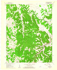
 1960 Winchester1960 Print · USGSCentral Kentucky's diverse landscape is shown here at mid-century, from the bluegrass plains to the rugged Pottsville Escarpment. Genealogists and historians can trace the rail-and-river network connecting towns like Bardstown and Stanford alongside landmarks like Lake Cumberland.
 - 1960 Map of Vine Grove, 1961 Print
 1960 Vine Grove1961 Print · USGSHardin County during the early sixties shows the interface between military growth and rural Kentucky life. Trace family roots at St Brigids Cem or follow the Illinois Central tracks through Vine Grove and Radcliff.5 unique versions available
 - 1960 Map of Cecilia, 1961 Print
 1960 Cecilia1961 Print · USGSHardin County during the early sixties shows a landscape shaped by the intersection of major rail lines and growing suburban footprints. Genealogists can locate family landmarks such as Bethlehem Academy, St Johns Ch, and the rural community of Kraft.
 - 1960 Map of Colesburg, 1961 Print
 1960 Colesburg1961 Print · USGSHardin and Bullitt counties are shown during the early 1960s as military and civilian landscapes converged along the Rolling Fork. Researchers can trace the path of the Louisville and Nashville Turnpike or locate family burial sites such as Sycamore Cem and Bowling Cem.3 unique versions available
 - 1960 Map of Elizabethtown, 1962 Print
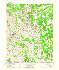
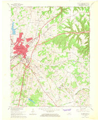
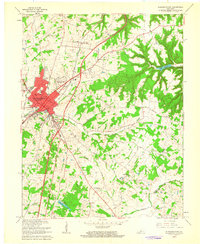 1960 Elizabethtown1962 Print · USGSElizabethtown and the surrounding Hardin County countryside are captured here in the early sixties as the toll road era begins. Researchers can trace family roots at Helm Cem and Browns Cem or locate old schoolhouses like Lincoln Trail Sch.2 unique versions available
 - 1967 Map of Elizabethtown, 1968 Print
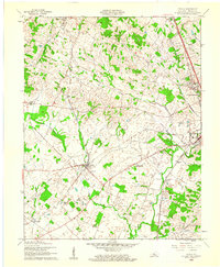
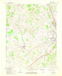
 1967 Elizabethtown1968 Print · USGSElizabethtown at the end of the sixties shows a landscape transformed by the new convergence of the Blue Grass Parkway and the Kentucky Toll Road. Genealogists can trace local roots at Helm Cem, Round Top Ch, and the old Tunnel Hill settlement.4 unique versions available
 - 1967 Map of Cecilia, 1968 Print
 1967 Cecilia1968 Print · USGSCecilia and western Elizabethtown are shown in the late sixties as the intersection of rail commerce and new highway infrastructure. Genealogists can trace family landmarks like St Johns Cem, the community at Rineyville, and the St Ambrose Ch.4 unique versions available
End of results
Showing maps 1-7 of 7
Top cities near Elizabethtown
- Radcliff historical maps
- Vine Grove historical maps
- Rineyville historical maps
- Hodgenville historical maps
- Lebanon Junction historical maps
- Sonora historical maps
Top neighborhoods of Elizabethtown
Frequently asked questions
- What are the different types of historical maps available for Elizabethtown?
- What is the oldest map of Elizabethtown?
- Where can I purchase historical maps of Elizabethtown for my home or office?
- Where can I download high-res historical maps of Elizabethtown?
- Are there historical topographic maps available for Elizabethtown?
- Is there historical aerial imagery available for Elizabethtown?
- Where are historical maps of Elizabethtown sourced from?