1970s Maps of Henderson County, Kentucky
Explore 4 historic maps of Henderson County from the 1970s. These maps offer a rare glimpse into what life looked like during the 1970s — showing old roads, neighborhoods, homes, and landmarks that have changed or disappeared over time.
Whether you're researching your family's past, planning a metal detecting trip, or studying how Henderson County's landscape evolved across the 1970s, these high-resolution maps are a powerful tool for exploring the history of this region.
- Focus on a specific era: All maps on this page are from the 1970s, giving you a focused view of this time period.
- See what’s changed: Compare century-old streets, trails, and buildings to today's modern landscape using overlays and satellite layers.
- Research with precision: Use these maps for genealogy, historical research, land use analysis, or educational projects.
- View, download, or print: Maps are fully viewable online in high resolution, and can be downloaded or printed for your own records.
Start exploring Henderson County's history through authentic maps from the 1970s. This is your window into the past.
Henderson County, KY maps
(4)- 1971 Map of Reed, 1973 Print
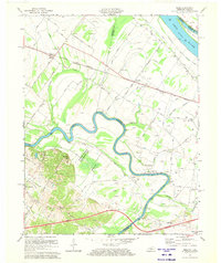 1971 Reed1973 Print · USGSThe Green River loops through Henderson and Daviess counties in the early seventies, where riverfront agriculture meets emerging oil production. Researchers can trace rural school and church sites like St Peters Sch and Pleasant Hill Ch or locate the scattered Oil Wells near Birk City.2 unique versions available
 - 1971 Map of Spottsville, 1973 Print
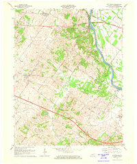 1971 Spottsville1973 Print · USGSHenderson County comes alive in the early seventies, showing a riverside landscape of oil production and navigation. Trace family landmarks along the Green River, including Lock and Dam No 1, Ridgewood Ch, and many scattered Oil Wells.2 unique versions available
 - 1971 Map of Henderson, 1973 Print
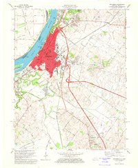 1971 Henderson1973 Print · USGSHenderson and the banks of the Ohio River are shown here in the early 1970s as the city expanded southward into the surrounding farmland. Researchers can trace family sites near Fernwood Cemetery, locate old schoolhouses like Audubon Mill Park School, or follow the Louisville and Nashville rail lines.4 unique versions available
 - 1978 Map of Caborn, 1979 Print
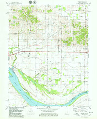 1978 Caborn1979 Print · USGSThe Indiana-Kentucky borderlands along the Ohio River appear here in the late seventies as a landscape of river industry and oil extraction. Trace family roots at St Johns Cem or follow the Louisville and Nashville Railroad through Bufkin and Caborn.2 unique versions available
End of results
Showing maps 1-4 of 4
Top cities of Henderson County
Frequently asked questions
- What are the different types of historical maps available for Henderson County?
- What is the oldest map of Henderson County?
- Where can I purchase historical maps of Henderson County for my home or office?
- Where can I download high-res historical maps of Henderson County?
- Are there historical topographic maps available for Henderson County?
- Is there historical aerial imagery available for Henderson County?
- Where are historical maps of Henderson County sourced from?