1980s Maps of Henderson, Kentucky
Explore 3 historic maps of Henderson from the 1980s. These maps offer a rare glimpse into what life looked like during the 1980s — showing old roads, neighborhoods, homes, and landmarks that have changed or disappeared over time.
Whether you're researching your family's past, planning a metal detecting trip, or studying how Henderson's landscape evolved across the 1980s, these high-resolution maps are a powerful tool for exploring the history of this region.
- Focus on a specific era: All maps on this page are from the 1980s, giving you a focused view of this time period.
- See what’s changed: Compare century-old streets, trails, and buildings to today's modern landscape using overlays and satellite layers.
- Research with precision: Use these maps for genealogy, historical research, land use analysis, or educational projects.
- View, download, or print: Maps are fully viewable online in high resolution, and can be downloaded or printed for your own records.
Start exploring Henderson's history through authentic maps from the 1980s. This is your window into the past.
Henderson, KY maps
(3)- 1981 Map of Wilson
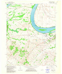 1981 Wilson1981 Print · USGSThe Ohio River borderlands of Henderson County appear here in the early eighties, balancing vast wetlands with rising industrial footprints. Genealogists can locate family-named sites like Clay Cem and Stroud Cem, while historians can trace the development of Geneva and the Henderson Community College.2 unique versions available
 - 1981 Map of Evansville South, 1982 Print
 1981 Evansville South1982 Print · USGSEvansville stands as a major river-and-rail hub along the Ohio River at the start of the eighties. Researchers can trace institutional history at Evansville University and Evansville State Hospital, or locate family sites at Oak Hill Cemetery.2 unique versions available
 - 1986 Map of Evansville
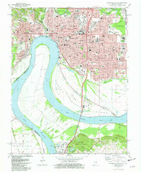
 1986 Evansville1986 Print · USGSThe Ohio River valley thrives in the mid-1980s as a hub of river commerce, industry, and natural preservation spanning the Indiana-Kentucky border. Genealogists and historians can locate remote landmarks like Dead Mans Cem, Lippe Church, and the riverside community of Scuffletown.
End of results
Showing maps 1-3 of 3
Top cities near Henderson
- Evansville historical maps
- Newburgh historical maps
- Chandler historical maps
- Sebree historical maps
- Corydon historical maps
- Robards historical maps
See more
Top neighborhoods of Henderson
Frequently asked questions
- What are the different types of historical maps available for Henderson?
- What is the oldest map of Henderson?
- Where can I purchase historical maps of Henderson for my home or office?
- Where can I download high-res historical maps of Henderson?
- Are there historical topographic maps available for Henderson?
- Is there historical aerial imagery available for Henderson?
- Where are historical maps of Henderson sourced from?