1930s Maps of Hickman County, Kentucky
Explore 2 historic maps of Hickman County from the 1930s. These maps offer a rare glimpse into what life looked like during the 1930s — showing old roads, neighborhoods, homes, and landmarks that have changed or disappeared over time.
Whether you're researching your family's past, planning a metal detecting trip, or studying how Hickman County's landscape evolved across the 1930s, these high-resolution maps are a powerful tool for exploring the history of this region.
- Focus on a specific era: All maps on this page are from the 1930s, giving you a focused view of this time period.
- See what’s changed: Compare century-old streets, trails, and buildings to today's modern landscape using overlays and satellite layers.
- Research with precision: Use these maps for genealogy, historical research, land use analysis, or educational projects.
- View, download, or print: Maps are fully viewable online in high resolution, and can be downloaded or printed for your own records.
Start exploring Hickman County's history through authentic maps from the 1930s. This is your window into the past.
Hickman County, KY maps
(2)- 1939 Map of Wickliffe
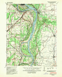 1939 Wickliffe1939 Print · USGSThe confluence of the Ohio and Mississippi Rivers in the late 1930s reveals a landscape of river-bend settlements and early flood control. Genealogists can locate numerous rural landmarks such as St Pauls Ch & Sch, Cherry Geveden Sch, and the historic site of Fort Jefferson.2 unique versions available
 - 1939 Map of Hickman, 1941 Print
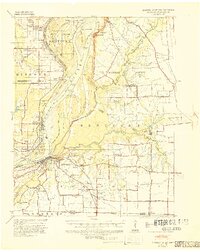 1939 Hickman1941 Print · USGSWestern Kentucky and the Missouri bootheel meet at the river in the late 1930s, showing a landscape of flood control and rural growth. Genealogists can locate family-named sites like Hubbard Cem, Stubbs Sch, and the riverside settlement of Dorena.4 unique versions available
End of results
Showing maps 1-2 of 2
Top cities of Hickman County
Frequently asked questions
- What are the different types of historical maps available for Hickman County?
- What is the oldest map of Hickman County?
- Where can I purchase historical maps of Hickman County for my home or office?
- Where can I download high-res historical maps of Hickman County?
- Are there historical topographic maps available for Hickman County?
- Is there historical aerial imagery available for Hickman County?
- Where are historical maps of Hickman County sourced from?