1960s Maps of Madisonville, Kentucky
Explore 4 historic maps of Madisonville from the 1960s. These maps offer a rare glimpse into what life looked like during the 1960s — showing old roads, neighborhoods, homes, and landmarks that have changed or disappeared over time.
Whether you're researching your family's past, planning a metal detecting trip, or studying how Madisonville's landscape evolved across the 1960s, these high-resolution maps are a powerful tool for exploring the history of this region.
- Focus on a specific era: All maps on this page are from the 1960s, giving you a focused view of this time period.
- See what’s changed: Compare century-old streets, trails, and buildings to today's modern landscape using overlays and satellite layers.
- Research with precision: Use these maps for genealogy, historical research, land use analysis, or educational projects.
- View, download, or print: Maps are fully viewable online in high resolution, and can be downloaded or printed for your own records.
Start exploring Madisonville's history through authentic maps from the 1960s. This is your window into the past.
Madisonville, KY maps
(4)- 1961 Map of Evansville
 1961 Evansville1961 Print · USGSThe Ohio River valley and its surrounding coalfields are captured here during the late fifties and early sixties. Trace the industrial rail networks of the Illinois Central RR and explore regional landmarks like Mammoth Cave National Park and Angel Mounds State Memorial.2 unique versions available
 - 1962 Map of Madisonville West, 1964 Print
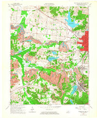 1962 Madisonville West1964 Print · USGSMid-century Hopkins County is defined here by the expansion of coal operations and suburban growth near Madisonville. Genealogists and historians can trace rail-side settlements like Manitou or locate family sites at Richland Cem and Carter Chapel.2 unique versions available
 - 1963 Map of Madisonville East, 1971 Print
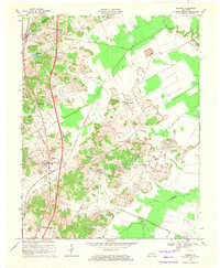
 1963 Madisonville East1971 Print · USGSThe coal country of eastern Hopkins County is captured here in the early sixties, as surface mining began to reshape the land. Genealogists and historians can trace the foundations of Madisonville, the grounds of the Tuberculosis Hospital, and the rural community at Bethlehem Ch.
 - 1969 Map of Hanson, 1971 Print
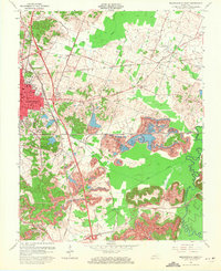
 1969 Hanson1971 Print · USGSNorth of Madisonville in the late sixties, this Hopkins and Webster County landscape shows a mix of coal-country industry and traditional rural life. Researchers can locate family landmarks like Pritchetts Chapel, Slaughters Lake, and the West Lawn Cem.
End of results
Showing maps 1-4 of 4
Top cities near Madisonville
- Providence historical maps
- Dawson Springs historical maps
- Earlington historical maps
- Nortonville historical maps
- Mortons Gap historical maps
- White Plains historical maps
See more
Top neighborhoods of Madisonville
Frequently asked questions
- What are the different types of historical maps available for Madisonville?
- What is the oldest map of Madisonville?
- Where can I purchase historical maps of Madisonville for my home or office?
- Where can I download high-res historical maps of Madisonville?
- Are there historical topographic maps available for Madisonville?
- Is there historical aerial imagery available for Madisonville?
- Where are historical maps of Madisonville sourced from?