1950s Maps of Middletown, Kentucky
Explore 8 historic maps of Middletown from the 1950s. These maps offer a rare glimpse into what life looked like during the 1950s — showing old roads, neighborhoods, homes, and landmarks that have changed or disappeared over time.
Whether you're researching your family's past, planning a metal detecting trip, or studying how Middletown's landscape evolved across the 1950s, these high-resolution maps are a powerful tool for exploring the history of this region.
- Focus on a specific era: All maps on this page are from the 1950s, giving you a focused view of this time period.
- See what’s changed: Compare century-old streets, trails, and buildings to today's modern landscape using overlays and satellite layers.
- Research with precision: Use these maps for genealogy, historical research, land use analysis, or educational projects.
- View, download, or print: Maps are fully viewable online in high resolution, and can be downloaded or printed for your own records.
Start exploring Middletown's history through authentic maps from the 1950s. This is your window into the past.
Middletown, KY maps
(8)- 1951 Map of Anchorage
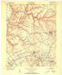 1951 Anchorage1951 Print · USGSJefferson and Oldham Counties appear here in the early fifties, showing a landscape defined by institutional campuses and rail-centered towns. Genealogists and historians can trace Ormsby Village, Berrytown, and the Kentucky Military Institute along the Louisville and Nashville Railroad.
 - 1951 Map of Crestwood
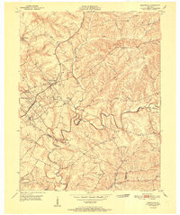 1951 Crestwood1951 Print · USGSThe railroad corridor between Oldham and Jefferson counties is well-established in the early fifties, centering on the growth of Crestwood and Pewee Valley. Researchers can locate historic institutions like the Pewee Valley Sanitarium and State Prison, or trace old family land near Pleasant Hill Cem and Glenarm.
 - 1951 Map of Jeffersontown
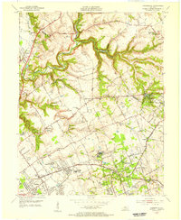
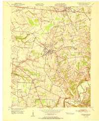 1951 Jeffersontown1951 Print · USGSEastern Jefferson County comes alive in the early fifties as the rural landscape between Jeffersontown and Middletown begins to develop. Genealogists and historians can trace family plots like Bullitt Cem and local landmarks like Eastern High Sch.
 - 1951 Map of Fisherville
 1951 Fisherville1951 Print · USGSEastern Jefferson County and the neighboring borderlands of Shelby and Spencer counties are captured here in the early fifties. Genealogists and local historians can trace the foundations of Fisherville, the grounds of the Lincoln Institute, and rural landmarks like Bethlehem Ch.
 - 1951 Map of Louisville, 1959 Print
 1951 Louisville1959 Print · USGSGreater Louisville and Bullitt County are seen here in a period of rapid suburban growth following the war. Researchers can trace family history through dozens of landmarks like Evergreen Cemetery, Camp Taylor, and the rural schools of Okolona.
 - 1955 Map of Jeffersontown, 1956 Print
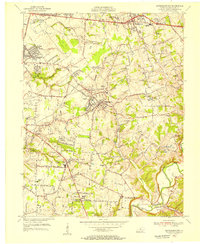 1955 Jeffersontown1956 Print · USGSJefferson County is shown in a period of significant growth during the mid-fifties, as suburban neighborhoods began to replace rural acreage. Genealogists and local historians can trace legacy sites like Spring Meadows Childrens Home, the Southern Railway, and old churches such as Beulah Ch.
 - 1955 Map of Anchorage, 1956 Print
 1955 Anchorage1956 Print · USGSEastern Jefferson County and the edge of Oldham County appear in the mid-fifties as a region of institutional campuses and established towns. Genealogists can trace family roots through Anchorage, Lyndon, and Griffytown, or locate landmarks like Central State Hospital and St Thomas Seminary.
 - 1956 Map of Louisville, 1971 Print
 1956 Louisville1971 Print · USGSThe Ohio River valley and the Kentucky Bluegrass are captured here during a period of rapid mid-century growth and industrial activity. Genealogists and historians can trace rail-centered towns and military land use at Fort Knox and the Jefferson Proving Ground.2 unique versions available
End of results
Showing maps 1-8 of 8
Top cities near Middletown
- Louisville historical maps
- Jeffersonville historical maps
- Jeffersontown historical maps
- Clarksville historical maps
- Mount Washington historical maps
- Lyndon historical maps
See more
Frequently asked questions
- What are the different types of historical maps available for Middletown?
- What is the oldest map of Middletown?
- Where can I purchase historical maps of Middletown for my home or office?
- Where can I download high-res historical maps of Middletown?
- Are there historical topographic maps available for Middletown?
- Is there historical aerial imagery available for Middletown?
- Where are historical maps of Middletown sourced from?