1980s Maps of Middletown, Kentucky
Explore 6 historic maps of Middletown from the 1980s. These maps offer a rare glimpse into what life looked like during the 1980s — showing old roads, neighborhoods, homes, and landmarks that have changed or disappeared over time.
Whether you're researching your family's past, planning a metal detecting trip, or studying how Middletown's landscape evolved across the 1980s, these high-resolution maps are a powerful tool for exploring the history of this region.
- Focus on a specific era: All maps on this page are from the 1980s, giving you a focused view of this time period.
- See what’s changed: Compare century-old streets, trails, and buildings to today's modern landscape using overlays and satellite layers.
- Research with precision: Use these maps for genealogy, historical research, land use analysis, or educational projects.
- View, download, or print: Maps are fully viewable online in high resolution, and can be downloaded or printed for your own records.
Start exploring Middletown's history through authentic maps from the 1980s. This is your window into the past.
Middletown, KY maps
(6)- 1981 Map of Anchorage, 1982 Print
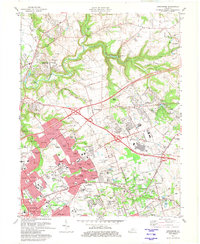 1981 Anchorage1982 Print · USGSSuburban Jefferson County comes into focus in the early eighties as highway expansion reshapes traditional neighborhoods. Genealogists and local historians can trace the footprint of Central State Hospital, the Kentucky Railway Museum, and settlements like Berrytown and O'Bannon.2 unique versions available
 - 1981 Map of Crestwood, 1982 Print
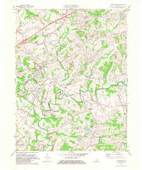 1981 Crestwood1982 Print · USGSThe rail-corridor towns of Oldham County are seen here in the early eighties as they balanced rural heritage with suburban growth. Genealogists and researchers can trace family landmarks like the Confederate Cem, St Aloysius Sch, and the State Correctional Institute for Women.2 unique versions available
 - 1982 Map of Fisherville
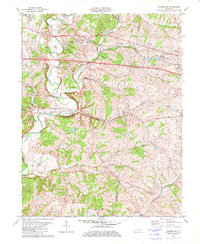 1982 Fisherville1982 Print · USGSEastern Jefferson County's rural landscape is captured here during the early eighties, showing the transition between farmsteads and suburban growth. Genealogists and locals can trace family lands near Fisherville, the Job Corps Center at Lincoln Ridge, and old rail stops like Boston.3 unique versions available
 - 1982 Map of Jeffersontown, 1983 Print
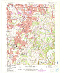
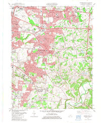 1982 Jeffersontown1983 Print · USGSJeffersontown and the eastern suburbs of Louisville are shown during a period of significant growth in the early eighties. Genealogists can trace family footprints through numerous local landmarks like St Pauls Ch, Seatonville, and Tucker Station.
 - 1984 Map of Jeffersontown, 1987 Print
 1984 Jeffersontown1987 Print · USGSEastern Jefferson County is shown in a phase of suburban maturation during the mid-eighties as Louisville expands eastward. Genealogists and local historians can trace family locations near Seatonville, Tucker Station, and the historic core of Jeffersontown.2 unique versions available
 - 1986 Map of Louisville
 1986 Louisville1986 Print · USGSMid-1980s Louisville and southern Indiana are shown here during a decade of significant suburban growth and infrastructure development. Researchers can trace the layout of Cave Hill Cemetery, the expansion of Standiford Field, and industrial sites like the Indiana Army Ammunition Plant.2 unique versions available
End of results
Showing maps 1-6 of 6
Top cities near Middletown
- Louisville historical maps
- Jeffersonville historical maps
- Jeffersontown historical maps
- Clarksville historical maps
- Mount Washington historical maps
- Lyndon historical maps
See more
Frequently asked questions
- What are the different types of historical maps available for Middletown?
- What is the oldest map of Middletown?
- Where can I purchase historical maps of Middletown for my home or office?
- Where can I download high-res historical maps of Middletown?
- Are there historical topographic maps available for Middletown?
- Is there historical aerial imagery available for Middletown?
- Where are historical maps of Middletown sourced from?