Old Maps of St. Matthews, Kentucky for Academic Research
Study the evolution of St. Matthews with 51 high-resolution historic maps. Whether you're teaching, researching, or modeling changes in land use, these maps provide essential visual documentation of urban, environmental, and geographic change.
- Analyze long-term change: Track patterns in development, transportation, and natural features.
- Ideal for environmental or urban studies: Support academic projects with primary historical map data.
- Use in the classroom or lab: Educators and researchers rely on these maps to bring historical context to life.
These maps are a powerful tool for teaching, research, and visualizing how St. Matthews has changed over the decades.
St. Matthews, KY maps
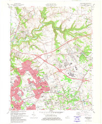
(51)- 1905 Map of Prospect, 1962 Print
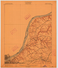
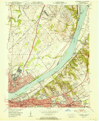
 1905 Prospect1962 Print · USGSThe Ohio River corridor north of Louisville comes alive in the early 1900s, showing a landscape of river landings and new electric railways. Researchers can find old landmarks like the Lakeland Asylum, the Kentucky Military Institute, and the Antioch Church.
 - 1907 Map of Louisville
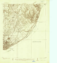
 1907 Louisville1907 Print · USGSLouisville and the rolling hills of Jefferson and Bullitt counties are captured here in the early 1900s. Researchers can trace ancestral connections through sites like Cave Hill Cemetery, Pleasant Grove Schoolhouse, and the river crossing at Bells Mill Ford.3 unique versions available
 - 1912 Map of Prospect
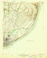
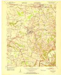
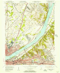
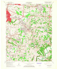
 1912 Prospect1912 Print · USGSThe northeastern outskirts of Louisville and the riverbanks of the Ohio River appear here in the early twentieth century. Researchers can trace the development of suburban settlements like Anchorage and St Matthews or locate the sprawling grounds of the Lakeland Asylum.3 unique versions available
 - 1937 Map of Jeffersonville
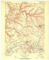
 1937 Jeffersonville1937 Print · USGSJeffersonville and the northern banks of the Ohio River appear here in the late 1930s, documenting a landscape shaped by early industry and river trade. Researchers can trace the path of the Indiana Railroad (Electric Line) and locate landmarks like Asbury Chapel and Walnut Ridge Cemetery.
 - 1946 Map of Jeffersonville
 1946 Jeffersonville1946 Print · USGSSouthern Indiana sits at a crossroads of river and rail during the mid-1940s, as the industrial grid of Jeffersonville meets the rural Clark Military Grant. Researchers can trace family roots at Walnut Ridge Cem or locate vanished schoolhouses like Lane Sch and Middle Road Sch.2 unique versions available
 - 1951 Map of Anchorage
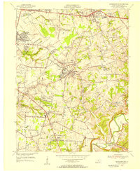
 1951 Anchorage1951 Print · USGSJefferson and Oldham Counties appear here in the early fifties, showing a landscape defined by institutional campuses and rail-centered towns. Genealogists and historians can trace Ormsby Village, Berrytown, and the Kentucky Military Institute along the Louisville and Nashville Railroad.
 - 1951 Map of Jeffersonville
 1951 Jeffersonville1951 Print · USGSThe Ohio River corridor near the Falls was a bustling hub of mid-century industry and suburban growth just after the war. Local historians can trace the footprints of the Indiana Arsenal, the Big Four RR Bridge, and old family landmarks from Claysburg to St Matthews.
 - 1951 Map of Louisville East
 1951 Louisville East1951 Print · USGSJefferson County is shown in the early fifties as the city reaches outward toward Okolona and Buechel. Researchers can trace old family burial grounds like Evergreen Cemetery and landmark institutions such as Standiford Field and the U S Army Medical Depot.
 - 1951 Map of Jeffersontown
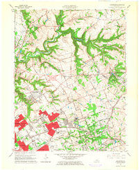
 1951 Jeffersontown1951 Print · USGSEastern Jefferson County comes alive in the early fifties as the rural landscape between Jeffersontown and Middletown begins to develop. Genealogists and historians can trace family plots like Bullitt Cem and local landmarks like Eastern High Sch.
 - 1951 Map of Louisville, 1959 Print
 1951 Louisville1959 Print · USGSGreater Louisville and Bullitt County are seen here in a period of rapid suburban growth following the war. Researchers can trace family history through dozens of landmarks like Evergreen Cemetery, Camp Taylor, and the rural schools of Okolona.
 - 1955 Map of Jeffersontown, 1956 Print
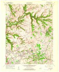
 1955 Jeffersontown1956 Print · USGSJefferson County is shown in a period of significant growth during the mid-fifties, as suburban neighborhoods began to replace rural acreage. Genealogists and local historians can trace legacy sites like Spring Meadows Childrens Home, the Southern Railway, and old churches such as Beulah Ch.
 - 1955 Map of Anchorage, 1956 Print
 1955 Anchorage1956 Print · USGSEastern Jefferson County and the edge of Oldham County appear in the mid-fifties as a region of institutional campuses and established towns. Genealogists can trace family roots through Anchorage, Lyndon, and Griffytown, or locate landmarks like Central State Hospital and St Thomas Seminary.
 - 1955 Map of Louisville East, 1956 Print
 1955 Louisville East1956 Print · USGSThe eastern reaches of Jefferson County in the mid-fifties show a landscape of rapid suburban growth and massive infrastructure. Trace early airport layouts at Standiford Field or locate family plots in Calvary Cemetery and St Michael Cemetery.
 - 1955 Map of Jeffersonville, 1957 Print
 1955 Jeffersonville1957 Print · USGSIn the mid-fifties, the riverfronts of Jeffersonville and Louisville were hubs of industry and suburban expansion. Researchers can trace family sites from Asbury Chapel to the Zachary Taylor National Cemetery, alongside the massive Indiana Arsenal.
 - 1956 Map of Louisville, 1971 Print
 1956 Louisville1971 Print · USGSThe Ohio River valley and the Kentucky Bluegrass are captured here during a period of rapid mid-century growth and industrial activity. Genealogists and historians can trace rail-centered towns and military land use at Fort Knox and the Jefferson Proving Ground.2 unique versions available
 - 1960 Map of Anchorage, 1961 Print
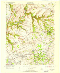
 1960 Anchorage1961 Print · USGSEastern Jefferson County is shown at a peak of institutional and suburban growth in the early sixties. Genealogists and historians can trace family locations near the Kentucky Military Institute, Anchorage, and Ormsby Village.
 - 1960 Map of Jeffersonville, 1961 Print
 1960 Jeffersonville1961 Print · USGSJeffersonville and Louisville are shown at a peak of mid-century growth as the river-and-rail economy defined the border between Indiana and Kentucky. Researchers can trace historic institutions and transport hubs, including the Zachary Taylor National Cemetery, the Indiana Arsenal, and the State Railway Museum.
 - 1960 Map of Jeffersontown, 1961 Print
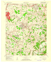 1960 Jeffersontown1961 Print · USGSEastern Jefferson County comes alive in this early 1960s survey, showing the transition from farmland to suburban neighborhoods. Genealogists and local historians can pinpoint family landmarks like Bullitt Cem, Tucker Station, and the Spring Meadows Childrens Home.
 - 1960 Map of Louisville East, 1961 Print
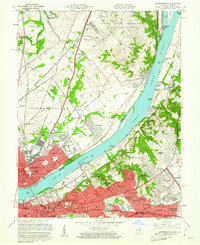
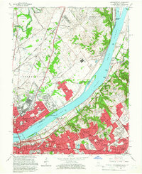
 1960 Louisville East1961 Print · USGSLouisville is captured during its mid-century expansion, as residential subdivisions and new expressways began to link the historic city core with its eastern suburbs. Trace the development of local institutions like Appliance Park, the runways of Bowman Field, and the grounds of Cave Hill Cemetery.
 - 1964 Map of Louisville
 1964 Louisville1964 Print · USGSThe Ohio River valley and Kentucky Bluegrass are captured in the mid-1960s, showing a region balanced between industrial growth and its agrarian roots. Genealogists and historians can trace the development of county seats like Shelbyville and Paris, or locate established institutions such as Georgetown College and Bernheim Forest.
 - 1964 Map of Jeffersontown, 1967 Print
 1964 Jeffersontown1967 Print · USGSEastern Jefferson County is shown at a peak of mid-century suburbanization as residential tracts begin to surround established towns like Jeffersontown and Middletown. Genealogists can trace family roots through sites like the Chenoweth Run Cemetery, Seatonville, and the Davis Memorial Chapel.2 unique versions available
 - 1965 Map of Anchorage, 1966 Print
 1965 Anchorage1966 Print · USGSEastern Jefferson County was undergoing a major residential and institutional transition in the mid-sixties. Researchers can trace the grounds of the Ormsby Village State Reservation, the Kentucky Military Institute, and the rail lines through Anchorage.2 unique versions available
 - 1965 Map of Jeffersonville, 1966 Print
 1965 Jeffersonville1966 Print · USGSThe riverfronts of southern Indiana and northern Kentucky are captured here in the mid-sixties, a period of significant suburban expansion. Researchers can trace historic sites like the Locust Grove Historical Home, Zachary Taylor National Cemetery, and the State Railway Museum.2 unique versions available
 - 1965 Map of Louisville East, 1967 Print
 1965 Louisville East1967 Print · USGSJefferson County experienced massive growth in the 1960s as the modern expressway system reshaped the eastern Louisville suburbs. Genealogists can trace family plots in Cave Hill Cemetery and Evergreen Cemetery or locate parish schools like St Ignatius Martyr Sch.2 unique versions available
 - 1981 Map of Anchorage, 1982 Print
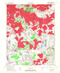
 1981 Anchorage1982 Print · USGSSuburban Jefferson County comes into focus in the early eighties as highway expansion reshapes traditional neighborhoods. Genealogists and local historians can trace the footprint of Central State Hospital, the Kentucky Railway Museum, and settlements like Berrytown and O'Bannon.2 unique versions available
Showing maps 1-25 of 51
Top cities near St. Matthews
- Louisville historical maps
- Jeffersonville historical maps
- New Albany historical maps
- Jeffersontown historical maps
- Clarksville historical maps
- Shively historical maps
See more
Top neighborhoods of St. Matthews
- Broad Fields historical maps
- Fairmeade historical maps
- Parkside historical maps
- Springlee historical maps
- Cherrywood Village historical maps
- Plymouth Village historical maps
See more
Frequently asked questions
- What are the different types of historical maps available for St. Matthews?
- What is the oldest map of St. Matthews?
- Where can I purchase historical maps of St. Matthews for my home or office?
- Where can I download high-res historical maps of St. Matthews?
- Are there historical topographic maps available for St. Matthews?
- Is there historical aerial imagery available for St. Matthews?
- Where are historical maps of St. Matthews sourced from?