1970s Maps of Knott County, Kentucky
Explore 4 historic maps of Knott County from the 1970s. These maps offer a rare glimpse into what life looked like during the 1970s — showing old roads, neighborhoods, homes, and landmarks that have changed or disappeared over time.
Whether you're researching your family's past, planning a metal detecting trip, or studying how Knott County's landscape evolved across the 1970s, these high-resolution maps are a powerful tool for exploring the history of this region.
- Focus on a specific era: All maps on this page are from the 1970s, giving you a focused view of this time period.
- See what’s changed: Compare century-old streets, trails, and buildings to today's modern landscape using overlays and satellite layers.
- Research with precision: Use these maps for genealogy, historical research, land use analysis, or educational projects.
- View, download, or print: Maps are fully viewable online in high resolution, and can be downloaded or printed for your own records.
Start exploring Knott County's history through authentic maps from the 1970s. This is your window into the past.
Knott County, KY maps
(4)- 1972 Map of Hazard North, 1973 Print
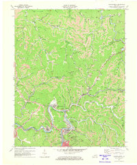 1972 Hazard North1973 Print · USGSThe coal country of Perry County is shown here in the early 1970s, at a time when industrial mining reshaped the landscape. Genealogists can trace family names through numerous remote burial sites and communities like Blue Diamond, Harveyton, and Hardburly.2 unique versions available
 - 1972 Map of Hazard South, 1973 Print
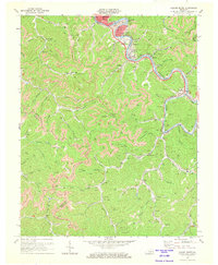 1972 Hazard South1973 Print · USGSPerry County coal country thrives along the river bends in the early seventies, centered on the growing industrial hub of Hazard. Genealogists and historians can trace deep-hollow settlements and hillside churches like Logwood Ch, Viper, and Fairview Chapel.2 unique versions available
 - 1977 Map of Pikeville, 1983 Print
 1977 Pikeville1983 Print · USGSThe Central Appalachian coalfields and the rugged borders of Kentucky and Virginia come into focus during the late seventies. Researchers can trace the rail networks of the C & O and L & N through towns like Jenkins, Whitesburg, and Pikeville.
 - 1977 Map of Hazard, 1983 Print
 1977 Hazard1983 Print · USGSEastern Kentucky's coal country comes into sharp focus during the late seventies, showing the deep-set river valleys and mountain gaps that shaped regional life. Genealogists can trace family connections through river-bottom settlements like Oneida, Krypton, and Bulan or follow the Seaboard System rail lines.
End of results
Showing maps 1-4 of 4
Top cities of Knott County
Frequently asked questions
- What are the different types of historical maps available for Knott County?
- What is the oldest map of Knott County?
- Where can I purchase historical maps of Knott County for my home or office?
- Where can I download high-res historical maps of Knott County?
- Are there historical topographic maps available for Knott County?
- Is there historical aerial imagery available for Knott County?
- Where are historical maps of Knott County sourced from?