1970s Maps of Magoffin County, Kentucky
Explore 2 historic maps of Magoffin County from the 1970s. These maps offer a rare glimpse into what life looked like during the 1970s — showing old roads, neighborhoods, homes, and landmarks that have changed or disappeared over time.
Whether you're researching your family's past, planning a metal detecting trip, or studying how Magoffin County's landscape evolved across the 1970s, these high-resolution maps are a powerful tool for exploring the history of this region.
- Focus on a specific era: All maps on this page are from the 1970s, giving you a focused view of this time period.
- See what’s changed: Compare century-old streets, trails, and buildings to today's modern landscape using overlays and satellite layers.
- Research with precision: Use these maps for genealogy, historical research, land use analysis, or educational projects.
- View, download, or print: Maps are fully viewable online in high resolution, and can be downloaded or printed for your own records.
Start exploring Magoffin County's history through authentic maps from the 1970s. This is your window into the past.
Magoffin County, KY maps
(2)- 1977 Map of Lenox, 1978 Print
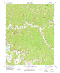 1977 Lenox1978 Print · USGSMorgan County is shown in the late seventies as a landscape of deep river bends and high knobs. Researchers can trace family names through numerous landmarks like Cottle Cem, Gordon Ford, and the Lick Branch Community Ctr.
 - 1977 Map of Pikeville, 1983 Print
 1977 Pikeville1983 Print · USGSThe Central Appalachian coalfields and the rugged borders of Kentucky and Virginia come into focus during the late seventies. Researchers can trace the rail networks of the C & O and L & N through towns like Jenkins, Whitesburg, and Pikeville.
End of results
Showing maps 1-2 of 2
Top cities of Magoffin County
Frequently asked questions
- What are the different types of historical maps available for Magoffin County?
- What is the oldest map of Magoffin County?
- Where can I purchase historical maps of Magoffin County for my home or office?
- Where can I download high-res historical maps of Magoffin County?
- Are there historical topographic maps available for Magoffin County?
- Is there historical aerial imagery available for Magoffin County?
- Where are historical maps of Magoffin County sourced from?