1990s Maps of Calvert City, Kentucky
Explore 1 historic maps of Calvert City from the 1990s. These maps offer a rare glimpse into what life looked like during the 1990s — showing old roads, neighborhoods, homes, and landmarks that have changed or disappeared over time.
Whether you're researching your family's past, planning a metal detecting trip, or studying how Calvert City's landscape evolved across the 1990s, these high-resolution maps are a powerful tool for exploring the history of this region.
- Focus on a specific era: All maps on this page are from the 1990s, giving you a focused view of this time period.
- See what’s changed: Compare century-old streets, trails, and buildings to today's modern landscape using overlays and satellite layers.
- Research with precision: Use these maps for genealogy, historical research, land use analysis, or educational projects.
- View, download, or print: Maps are fully viewable online in high resolution, and can be downloaded or printed for your own records.
Start exploring Calvert City's history through authentic maps from the 1990s. This is your window into the past.
Calvert City, KY maps
(1)- 1993 Map of Calvert City, 1996 Print
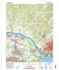 1993 Calvert City1996 Print · USGSKentucky's riverfront undergoes a profound transformation in the late twentieth century as industrial growth meets recreation near the Tennessee River. Genealogists and historians can locate family cemeteries like Ramage Cem, old river sites like Cooper Landing, and the massive Kentucky Dam.
End of results
Showing maps 1-1 of 1
Top cities near Calvert City
- Paducah historical maps
- Reidland historical maps
- Benton historical maps
- Kuttawa historical maps
- Smithland historical maps
- Grand Rivers historical maps
Top neighborhoods of Calvert City
Frequently asked questions
- What are the different types of historical maps available for Calvert City?
- What is the oldest map of Calvert City?
- Where can I purchase historical maps of Calvert City for my home or office?
- Where can I download high-res historical maps of Calvert City?
- Are there historical topographic maps available for Calvert City?
- Is there historical aerial imagery available for Calvert City?
- Where are historical maps of Calvert City sourced from?