1960s Maps of Menifee County, Kentucky
Explore 5 historic maps of Menifee County from the 1960s. These maps offer a rare glimpse into what life looked like during the 1960s — showing old roads, neighborhoods, homes, and landmarks that have changed or disappeared over time.
Whether you're researching your family's past, planning a metal detecting trip, or studying how Menifee County's landscape evolved across the 1960s, these high-resolution maps are a powerful tool for exploring the history of this region.
- Focus on a specific era: All maps on this page are from the 1960s, giving you a focused view of this time period.
- See what’s changed: Compare century-old streets, trails, and buildings to today's modern landscape using overlays and satellite layers.
- Research with precision: Use these maps for genealogy, historical research, land use analysis, or educational projects.
- View, download, or print: Maps are fully viewable online in high resolution, and can be downloaded or printed for your own records.
Start exploring Menifee County's history through authentic maps from the 1960s. This is your window into the past.
Menifee County, KY maps
(5)- 1960 Map of Jenkins
 1960 Jenkins1960 Print · USGSEastern Kentucky and the West Virginia borderlands are captured at a mid-century peak of the coal and rail era. Trace the industrial corridors of the Chesapeake and Ohio RR through mountain hubs like Hazard and Jenkins.
 - 1960 Map of Huntington
 1960 Huntington1960 Print · USGSThe tri-state river valley thrived in the late fifties as a hub of heavy industry and Appalachian rail transit. Genealogists and historians can trace the connection between river towns like Ashland and Portsmouth or locate family homesteads near Coleman Ridge.
 - 1965 Map of Hazel Green, 1967 Print
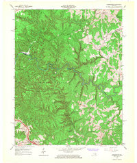
 1965 Hazel Green1967 Print · USGSThe Red River Valley in the mid-1960s reveals a rural landscape defined by narrow hollows and ridge-line communities along the Morgan and Wolfe County line. Researchers can locate specific family-named landmarks and institutions like the Hazel Green Academy, Flat Rock Ch, and early Oil Wells.3 unique versions available
 - 1966 Map of Pomeroyton, 1968 Print
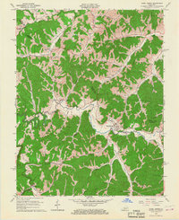
 1966 Pomeroyton1968 Print · USGSThe Red River Gorge area comes to life in the mid-sixties, highlighting the rugged settlement patterns of Wolfe and Menifee Counties. Trace local landmarks like the Dessie Scott Childrens Home, Calaboose Sch, and geological wonders from Sky Bridge to Tower Rock.4 unique versions available
 - 1966 Map of Slade, 1968 Print
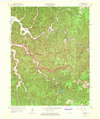 1966 Slade1968 Print · USGSThe Red River Gorge region comes alive in the mid-1960s as new highways began to meet traditional mountain settlements. Genealogists and hikers can trace old homesites near Nada, locate the Middle Fork Ch, or follow the path of the Mountain Central Railroad.2 unique versions available
End of results
Showing maps 1-5 of 5
Top cities of Menifee County
Frequently asked questions
- What are the different types of historical maps available for Menifee County?
- What is the oldest map of Menifee County?
- Where can I purchase historical maps of Menifee County for my home or office?
- Where can I download high-res historical maps of Menifee County?
- Are there historical topographic maps available for Menifee County?
- Is there historical aerial imagery available for Menifee County?
- Where are historical maps of Menifee County sourced from?