1900-1909 Maps of Muhlenberg County, Kentucky
Explore 3 historic maps of Muhlenberg County from 1900-1909. These maps offer a rare glimpse into what life looked like during the 1900s — showing old roads, neighborhoods, homes, and landmarks that have changed or disappeared over time.
Whether you're researching your family's past, planning a metal detecting trip, or studying how Muhlenberg County's landscape evolved across the 1900s, these high-resolution maps are a powerful tool for exploring the history of this region.
- Focus on a specific era: All maps on this page are from the 1900s, giving you a focused view of this time period.
- See what’s changed: Compare century-old streets, trails, and buildings to today's modern landscape using overlays and satellite layers.
- Research with precision: Use these maps for genealogy, historical research, land use analysis, or educational projects.
- View, download, or print: Maps are fully viewable online in high resolution, and can be downloaded or printed for your own records.
Start exploring Muhlenberg County's history through authentic maps from the 1900s. This is your window into the past.
Muhlenberg County, KY maps
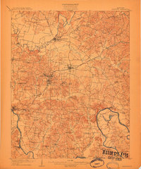
(3)- 1909 Map of Madisonville
 1909 Madisonville1909 Print · USGSWestern Kentucky at the peak of the coal and rail era shows a landscape defined by river crossings and growing mining towns. Researchers can locate dozens of early rural landmarks, from Island Ford and Barnsley to the New Providence School and Brier Creek Church.3 unique versions available
 - 1909 Map of Hartford
 1909 Hartford1909 Print · USGSOhio County and the Green River valley are captured here just after the turn of the century, when river ferries and coal rail lines drove the local economy. Trace the old ferry crossings like Stroud Ferry and mining centers at Taylor Mines and Render.2 unique versions available
 - 1909 Map of Central City
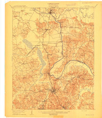 1909 Central City1909 Print · USGSWestern Kentucky's coal and river country comes alive in this early century survey of Muhlenberg, McLean, and Ohio counties. Researchers can trace historic river crossings at Kinchloe Ferry and Knotts Ferry or locate old community hubs like Shavers Chapel and Moorman.3 unique versions available
End of results
Showing maps 1-3 of 3
Top cities of Muhlenberg County
- Central City historical maps
- Greenville historical maps
- Powderly historical maps
- Drakesboro historical maps
- Bremen historical maps
- South Carrollton historical maps
Frequently asked questions
- What are the different types of historical maps available for Muhlenberg County?
- What is the oldest map of Muhlenberg County?
- Where can I purchase historical maps of Muhlenberg County for my home or office?
- Where can I download high-res historical maps of Muhlenberg County?
- Are there historical topographic maps available for Muhlenberg County?
- Is there historical aerial imagery available for Muhlenberg County?
- Where are historical maps of Muhlenberg County sourced from?