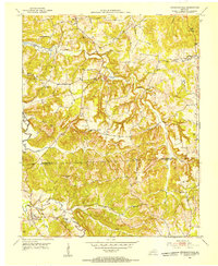
Old Maps of Muhlenberg County, Kentucky for Metal Detecting
Plan your next treasure hunt with 124 historic maps of Muhlenberg County. Find old homesites, ghost towns, trails, and gathering spots that may be lost to time — perfect for identifying promising metal detecting locations.
- Locate forgotten sites: Uncover places like long-lost settlements, abandoned rail lines, or gathering spots.
- Plan better hunts: Use map overlays combined with LiDAR or satellite views to narrow in on historically rich areas.
- Made for detectorists: Thousands of hobbyists use these maps to discover relics, coins, and hidden history.
Use these historic maps to boost your research and find new opportunities beneath the surface of Muhlenberg County.
Muhlenberg County, KY maps
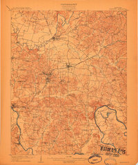
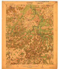
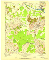
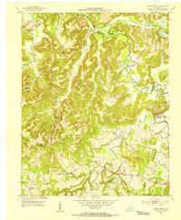
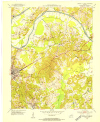
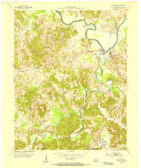
(124)- 1909 Map of Madisonville
 1909 Madisonville1909 Print · USGSWestern Kentucky at the peak of the coal and rail era shows a landscape defined by river crossings and growing mining towns. Researchers can locate dozens of early rural landmarks, from Island Ford and Barnsley to the New Providence School and Brier Creek Church.3 unique versions available
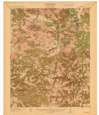
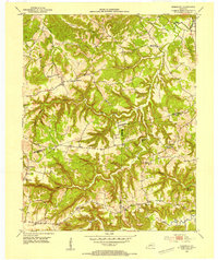
 - 1909 Map of Hartford
 1909 Hartford1909 Print · USGSOhio County and the Green River valley are captured here just after the turn of the century, when river ferries and coal rail lines drove the local economy. Trace the old ferry crossings like Stroud Ferry and mining centers at Taylor Mines and Render.2 unique versions available
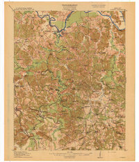
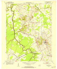
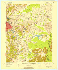
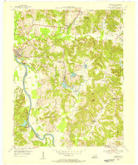
 - 1909 Map of Central City
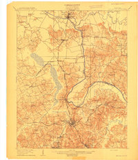 1909 Central City1909 Print · USGSWestern Kentucky's coal and river country comes alive in this early century survey of Muhlenberg, McLean, and Ohio counties. Researchers can trace historic river crossings at Kinchloe Ferry and Knotts Ferry or locate old community hubs like Shavers Chapel and Moorman.3 unique versions available
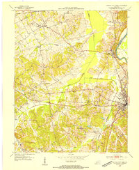
 - 1911 Map of Drakesboro
 1911 Drakesboro1911 Print · USGSMuhlenberg County was a landscape of dense rural school districts and emerging rail towns just before the Great War. Genealogists can trace family names through landmarks like Mays Store, Rhodes Chapel, and the uniquely named settlement of Lickskillet.
 - 1911 Map of Dunmor
 1911 Dunmor1911 Print · USGSMuhlenberg and Butler Counties are shown here just before the Great War, when river ferries and small rural schools anchored local life. Genealogists can trace family footprints at Mining City, Ebenezer Church, and the river landings near Skilesville.
 - 1912 Map of Nortonville
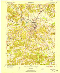
 1912 Nortonville1912 Print · USGSWestern Kentucky at the start of the decade is defined here by its busy rail junctions and rural merchant economy. Genealogists and historians can trace family roots through numerous country schools and stores, including Clement School, Jordons Store, and Greens Chapel.3 unique versions available
 - 1913 Map of Drakesboro
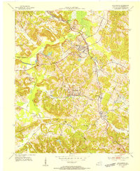
 1913 Drakesboro1913 Print · USGSMuhlenberg County in the early twentieth century was a bustling intersection of coal mining and major rail lines. Genealogists and historians can trace dozens of early rural schools and crossroads stores like Liberty Hill School, Belton Jost PO, and Dixon's Store.2 unique versions available
 - 1914 Map of Dunmor
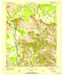
 1914 Dunmor1914 Print · USGSWestern Kentucky in the early twentieth century is defined by the river-borne trade of the Green River and the rural industry of the Mud River Mine. Genealogists and historians can trace defunct post offices like Boston Herschel PO and family-named crossings including Arnolds Bridge and Doolins Ferry.
 - 1952 Map of Equality, 1953 Print
 1952 Equality1953 Print · USGSThe confluence of the Green and Rough rivers comes into focus in the early 1950s, highlighting the borderlands of Ohio and McLean counties. Trace the river economy and family history through U S Lock No 1, Matanzas, and the Equality Ch.3 unique versions available
 - 1952 Map of Livermore, 1953 Print
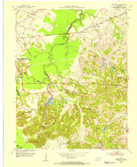
 1952 Livermore1953 Print · USGSMcLean County at the start of the 1950s shows a landscape shaped by river commerce and the extractive industry. Genealogists and historians can trace family locations near Livermore, find remote burial sites like Shavers Cem, or locate the Oil Wells of the era.3 unique versions available
 - 1952 Map of Sacramento, 1953 Print
 1952 Sacramento1953 Print · USGSMcLean County and the surrounding river bottoms are captured here in the early fifties, centered on the community of Sacramento. Local historians can trace early petroleum sites like an Oil Well and rural landmarks such as West Chapel and Brazzel Bridge.2 unique versions available
 - 1952 Map of Greenville, 1954 Print
 1952 Greenville1954 Print · USGSGreenville and the surrounding Muhlenberg County coalfields are captured here in the early fifties during a period of heavy mineral extraction. Genealogists and historians can locate family landmarks such as Mc Johnson School, Evergreen Cemetery, and the Buck Knob Lookout Tower.
 - 1953 Map of Drakesboro, 1954 Print
 1953 Drakesboro1954 Print · USGSIn the early 1950s, the Muhlenberg County coal and rail economy was in full swing around Drakesboro. Genealogists and historians can trace family cemeteries like Wilcox Cem alongside industrial markers like the Strip Mine and Louisville and Nashville railroad lines.
 - 1953 Map of Haleys Mill, 1954 Print
 1953 Haleys Mill1954 Print · USGSNorthwestern Christian County in the early fifties is captured here as a network of creek-side settlements and family homesteads. Genealogists can locate numerous burial grounds and rural congregations like Prowse Cem, Haleys Mill, and Judge Chapel.2 unique versions available
 - 1953 Map of Rosewood, 1954 Print
 1953 Rosewood1954 Print · USGSThe intersection of Muhlenberg, Todd, and Logan Counties in the early 1950s reveals a classic Kentucky ridge-and-hollow landscape. Genealogists can trace family footprints through rural landmarks like Tyewhoppety, New Harmony Ch, and Greenbrier Sch.
 - 1953 Map of Madisonville East, 1954 Print
 1953 Madisonville East1954 Print · USGSThe coal-rich corridor of Hopkins County is revealed in the early fifties, showing the heavy intersection of industry and community. Genealogists and researchers can trace family landmarks like St Marys Ch, Barnsley, and the extensive Strip Mines that shaped this landscape.
 - 1953 Map of Central City West, 1954 Print
 1953 Central City West1954 Print · USGSWestern Muhlenberg County is documented here in the early fifties, showing the area as the local economy shifted toward industrial coal production. Genealogists can trace family roots through numerous country landmarks like Shavers Chapel, Midland Sch, and the Evergreen Cem near the Green River.
 - 1953 Map of Central City East, 1954 Print
 1953 Central City East1954 Print · USGSMuhlenberg County in the early 1950s was a bustling hub of rail transport and coal production along the river. Genealogists can trace family roots through several local landmarks like Richardson Chapel, Fairmount Cem, and the communities of Cleaton and Ceralvo.
 - 1953 Map of Dunmor, 1954 Print
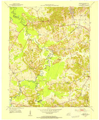
 1953 Dunmor1954 Print · USGSThe rural borders of Muhlenberg, Butler, and Logan Counties are captured in the early fifties, showing a landscape of ridge-top settlements and river bottomlands. Researchers can find ancestral sites from Old Hebron Ch to Forgys Mill and Hollow Bill.2 unique versions available
 - 1953 Map of Millport, 1954 Print
 1953 Millport1954 Print · USGSWestern Kentucky coal country in the early fifties shows a landscape balancing river bottom agriculture with industrial expansion. Trace family roots at Antioch Ch, locate Millport on the rail line, or map the early footprints of the Strip Mine fields.
 - 1953 Map of Graham, 1954 Print
 1953 Graham1954 Print · USGSWestern Kentucky coal country and river bottomlands come alive in the early fifties, documenting the landscape of the Pond River forks. Genealogists and historians can trace community roots through numerous landmarks like Yeargins Chapel, Mt Carmel, and the Illinois Central rail line.
 - 1953 Map of Rochester, 1954 Print
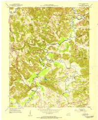
 1953 Rochester1954 Print · USGSThe Green River valley in the early fifties shows a bustling network of river towns and rural school districts at the junction of three counties. Researchers can trace family sites near Rochester, find old schoolhouses like Mud River Mine Sch, or locate the Lock No 3 river works.2 unique versions available
 - 1953 Map of Kirkmansville, 1955 Print
 1953 Kirkmansville1955 Print · USGSThe rural border of Muhlenberg and Todd counties comes to life in the early 1950s, showing a landscape of ridge-top farms and creek-bottom roads. Family historians can trace ancestral roots through dozens of local sites like Kirkmansville, Cherry Grove Ch, and the Sears Home Cem.2 unique versions available
 - 1954 Map of Evansville
 1954 Evansville1954 Print · USGSThe Ohio River borderlands between Indiana and Kentucky appear here during a period of robust industrial and military growth. Genealogists and researchers can trace the rail corridors of the Illinois Central and find landmarks like US Lock and Dam No 48 or Camp Breckinridge.
 - 1954 Map of Paradise, 1955 Print
 1954 Paradise1955 Print · USGSWestern Kentucky's river and rail economy is captured here in the mid-fifties, centered on the winding Green River. Genealogists and historians can trace family locations near Paradise, the Airdrie Iron Furnace, and country churches like Taylortown Ch.
Showing maps 1-25 of 124
Top cities of Muhlenberg County
- Central City historical maps
- Greenville historical maps
- Powderly historical maps
- Drakesboro historical maps
- Bremen historical maps
- South Carrollton historical maps
Frequently asked questions
- What are the different types of historical maps available for Muhlenberg County?
- What is the oldest map of Muhlenberg County?
- Where can I purchase historical maps of Muhlenberg County for my home or office?
- Where can I download high-res historical maps of Muhlenberg County?
- Are there historical topographic maps available for Muhlenberg County?
- Is there historical aerial imagery available for Muhlenberg County?
- Where are historical maps of Muhlenberg County sourced from?