
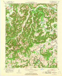
1953 Map of Haleys Mill
USGS Topo · Published 1954About this map
The West Fork Pond River meanders across the borderlands of Christian, Muhlenberg, and Todd Counties, anchoring a rural Kentucky landscape defined by winding watercourses and family-named landmarks. Small agrarian hubs such as Apex and Fruit Hill serve as community anchors, while the eponymous Haleys Mill sits along Wildcat Creek. The density of family cemeteries, including Atkinson Cem, Prowse Cem, and Bass Cem, suggests a long-settled population with deep ancestral roots in these hills.
Find a feature on this map
37 named features on this map. Tap any name to fly to it.
Don’t see what you’re looking for? This feature index may not catch every label — zoom into the map to look around manually.
Map Details
Editions of this 1953 Haleys Mill Map
2 editions found
Other maps of this area

1911 · Drakesboro
USGS Topo · 1:48,000

1912 · Nortonville
USGS Topo · 1:62,500

1913 · Drakesboro
USGS Topo · 1:62,500

1952 · Kelly
USGS Topo · 1:24,000

1952 · Allegre
USGS Topo · 1:24,000

1952 · Honey Grove
USGS Topo · 1:24,000

1952 · Greenville
USGS Topo · 1:24,000

1952 · Crofton
USGS Topo · 1:24,000

1953 · Nortonville
USGS Topo · 1:24,000
1953 · Graham
USGS Topo · 1:24,000