
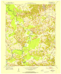
1952 Map of Crofton
USGS Topo · Published 1954About this map
Crofton serves as a central hub in this early 1950s survey of western Kentucky, situated where the Louisville and Nashville railroad tracks parallel U.S. 41. The landscape is a mix of agricultural clearings and dense woodland, particularly along the meandering course of the West Fork Pond River and its tributaries like McFarland Creek. This era of the region is defined by a reliance on both the land and the rail, with evidence of resource extraction shown at the strip mine near Mannington and several scattered gas wells. Local life is anchored by numerous small community landmarks, from rural schoolhouses like Orange Grove Sch to historic congregations at Old Petersburg Ch and Coal Chapel. The map is particularly rich for genealogical research, documenting over a dozen family-named burial grounds including Monk-Radliff Cem and Wynns Cem.
Find a feature on this map
33 named features on this map. Tap any name to fly to it.
Don’t see what you’re looking for? This feature index may not catch every label — zoom into the map to look around manually.
Map Details
Editions of this 1952 Crofton Map
This is the sole edition of this map. No revisions or reprints were ever made.
Other maps of this area

1909 · Dawson Springs
USGS Topo · 1:48,000

1911 · Dawson Springs
USGS Topo · 1:62,500

1912 · Nortonville
USGS Topo · 1:62,500

1952 · Pleasant Green Hill
USGS Topo · 1:24,000

1952 · Kelly
USGS Topo · 1:24,000

1952 · Honey Grove
USGS Topo · 1:24,000

1953 · Dawson Springs SE
USGS Topo · 1:24,000

1953 · Haleys Mill
USGS Topo · 1:24,000

1953 · Nortonville
USGS Topo · 1:24,000
1953 · Graham
USGS Topo · 1:24,000