
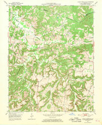
1953 Map of Dawson Springs SE
USGS Topo · Published 1953About this map
The Tradewater River winds through this 1953 landscape, marking the boundary between Hopkins and Christian counties. This area of western Kentucky is defined by its rural infrastructure and emerging industrial activity, with several Strip Mine and Strip Mines operations appearing alongside established farming settlements like Empire and Consolation. The map provides a detailed view of the social fabric of the era, recording numerous family-named burial grounds including Adams Cem, Mc Knight Cem, and Reynolds Cem. Notable local landmarks such as Pooles Mill Bridge and the Consolation Sch stand as evidence of the community's mid-century footprint. The winding courses of Castleberry Creek and Morgan Creek further carve through the terrain, illustrating the water-rich geography that supported the early growth of this region before extensive modern development changed the landscape.
Find a feature on this map
37 named features on this map. Tap any name to fly to it.
Don’t see what you’re looking for? This feature index may not catch every label — zoom into the map to look around manually.
Map Details
Editions of this 1953 Dawson Springs SE Map
2 editions found
Other maps of this area

1909 · Dawson Springs
USGS Topo · 1:48,000

1911 · Dawson Springs
USGS Topo · 1:62,500

1912 · Nortonville
USGS Topo · 1:62,500

1952 · Pleasant Green Hill
USGS Topo · 1:24,000

1952 · Kelly
USGS Topo · 1:24,000

1952 · Crofton
USGS Topo · 1:24,000

1953 · Nortonville
USGS Topo · 1:24,000

1953 · Gracey
USGS Topo · 1:24,000

1953 · Dawson Springs SW
USGS Topo · 1:24,000

1954 · Evansville
USGS Topo · 1:250,000