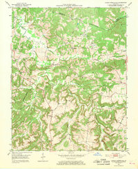
1953 Map of Dawson Springs SE
USGS Topo · Published 1968About this map
The Tradewater River and its meandering tributaries, including Castleberry Creek and Sandlick Creek, define this rural landscape on the border of Hopkins and Christian Counties. By the early 1950s, the region's economy was a mix of agriculture and emerging heavy industry, evidenced by the numerous Strip Mine excavations appearing in the northern hills. These industrial scars stand in contrast to the established social fabric of the countryside, where small communities like Empire and Era are anchored by landmarks such as Consolation Sch and Castleberry Ch. The western edge of the map is dominated by the Pennyrile State Forest Park Boundary, preserving a large tract of woodland. For genealogists, the map is particularly rich in family history, identifying over a dozen small burial grounds including the Mc Knight Cem, Adams Cem, and Cansler Cem, many of which are tucked away near farmsteads or along the winding creek forks.
Find a feature on this map
34 named features on this map. Tap any name to fly to it.
Don’t see what you’re looking for? This feature index may not catch every label — zoom into the map to look around manually.
Map Details
Editions of this 1953 Dawson Springs SE Map
2 editions found
Other maps of this area

1909 · Dawson Springs
USGS Topo · 1:48,000

1911 · Dawson Springs
USGS Topo · 1:62,500

1912 · Nortonville
USGS Topo · 1:62,500

1952 · Pleasant Green Hill
USGS Topo · 1:24,000

1952 · Kelly
USGS Topo · 1:24,000

1952 · Crofton
USGS Topo · 1:24,000

1953 · Dawson Springs SE
USGS Topo · 1:24,000

1953 · Nortonville
USGS Topo · 1:24,000

1953 · Gracey
USGS Topo · 1:24,000

1953 · Dawson Springs SW
USGS Topo · 1:24,000