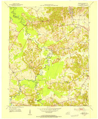
1953 Map of Graham
USGS Topo · Published 1954About this map
The winding Pond River and its multiple forks create a complex drainage system along the borders of Muhlenberg, Hopkins, and Christian Counties. During this early 1950s survey, the area around Graham and Graham Sta reflects an economy tied to both the Illinois Central railroad and the burgeoning coal industry, evidenced by prominent Strip Mines in the northwestern corner. The rural landscape is densely dotted with community landmarks, including numerous family-named burial grounds like Oglesby Cem and Sharbers Cem. Educational and spiritual centers such as Vernal Grove Sch and Yeargins Chapel are scattered throughout the hills, while river crossings like Jethro Ford indicate how locals navigated the many creeks before modern infrastructure. The map also documents several small settlements such as McNary, Bakersport, and Bancroft that served as local hubs during this period.
Find a feature on this map
39 named features on this map. Tap any name to fly to it.
Don’t see what you’re looking for? This feature index may not catch every label — zoom into the map to look around manually.
Map Details
Editions of this 1953 Graham Map
This is the sole edition of this map. No revisions or reprints were ever made.
Other maps of this area

1909 · Madisonville
USGS Topo · 1:62,500

1909 · Central City
USGS Topo · 1:62,500

1911 · Drakesboro
USGS Topo · 1:48,000

1912 · Nortonville
USGS Topo · 1:62,500

1913 · Drakesboro
USGS Topo · 1:62,500

1952 · Greenville
USGS Topo · 1:24,000

1952 · Crofton
USGS Topo · 1:24,000

1953 · Haleys Mill
USGS Topo · 1:24,000

1953 · Nortonville
USGS Topo · 1:24,000

1953 · Madisonville East
USGS Topo · 1:24,000